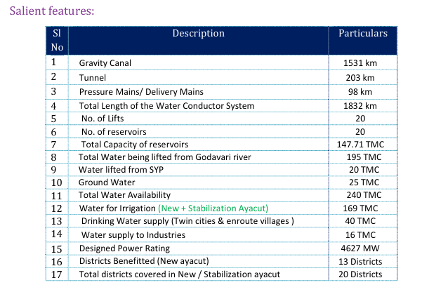
Construction of one barrage across river Godavari at Medigadda near Kaleshwaram, and two more 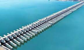 barrages between Medigadda and Sripada Yellampally Project at Annaram & Sundilla, and to convey water from Sripada Yellampally Project to the command area spread over in 7 districts of Telangana (now 13 districts after re-organization of districts in the state) through components such as canals, tunnels, lift systems, reservoirs, and distributory network for irrigating an ayacut of 18,25,700 acres against the original proposed ayacut of 16,40,000 acres. Further, it is proposed to stabilize the existing ayacut in other major projects viz., SRSP Stage-I, SRSP Stage-II, Flood Flow Canal, Singur & Nizamsagar projects to an extent of 18,82,970 acres. Besides irrigation, drinking water (30 TMC for twin cities & 10 TMC for enroute villages) & water for industrial use (16 TMC) is also proposed.
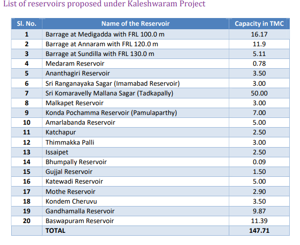
Further, after careful planning, the proposed capacity of reservoirs is increased from 11.43 TMC to 147.71 TMC by enhancing the capacities of existing reservoirs and proposing new reservoirs to match the demand and supply.
Salient Features of Link-1
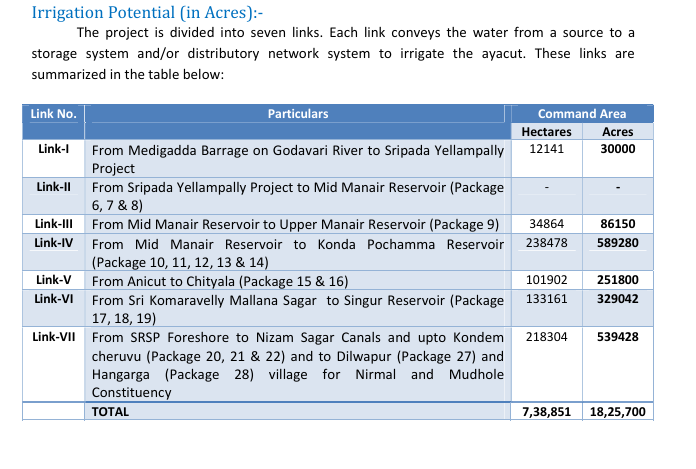
Link 1 of the project consists of construction of three barrages at Medigadda, Annaram and Sundilla barrages with a storage of almost 33 TMC and it is planned to lift the water through these barrages to Sripada Yellampalli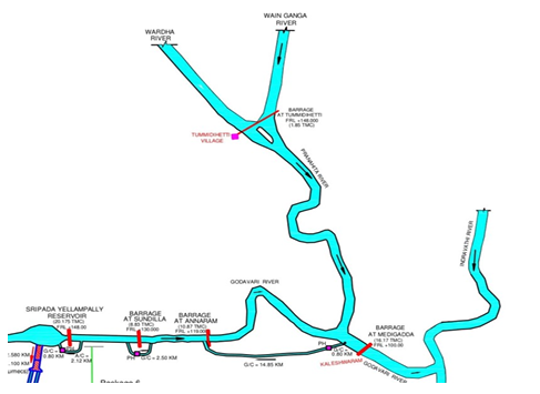 reservoir via three lift systems at Medigadda, Annaram and Sundilla by means of conveyor system consisting of approach channel, gravity canals and delivery mains (Pipelines). The link is critical for lifting water from Godavari and dropping into Sripada Yellampally Project, which can then be conveyed further to feed various reservoirs and serve the command area under different Packages in other links.
The total length of the link is 46.30 Km. An Approach channel of length 8.1 Km, Gravity Canal of 16.3 Km and delivery mains of total length 21.95 Km is provided.
Salient Features of Link-2
Link 2 carries water from Sripada Yellampalli reservoir to Mid-manair Reservoir, and feeding Medaram tank

along the way. From Mid-Manair reservoir, water can further be conveyed to the downstream links 3, 4, 5 & 6. This link has no direct ayacut. This link is characterized by tunnels, canals and pump houses consisting of pumps and motors with huge capacity.
This link comprises of 3 sub links with a gravity canal of 12.20 km length, a twin tunnel each of 10 m diameter and total length of 49.80 km (2 X 24.9 Km) and delivery mains of total length 3.64 Km. The total length of conveyor system of Link – II is about 65.63 Km.
Salient Features of Link-3

Link 3 is proposed to convey water from Mid Manair Reservoir to Upper Manair Reservoir, feeding Malkapet Reservoir along the way. Link 3 is proposed to serve an ayacut of 86,150 Ac.
The link involves a gravity canal of 27.50 Km, tunnel of 12 Km length and pressure main of total length 5.92 Km. The total length of the conveyor system of Link III is about 45.48 Km.
Salient Features of Link-4
 Link-4 is proposed to convey water from Mid manair Reservoir to Kondapochamma Sagar and feeding Ananthagiri, Sri Komaravelli Mallana Sagar, Sri Ranganayaka Sagar Reservoirs on the way. The total storage capacity along these packages is 71.5 TMC and total ayacut served through the Link is 5,89,280 acres.
The Link Canal System IV comprises 5 sub links with an open gravity channel of 394.0 Km, tunnel of 41.40 Km length and delivery mains of total length 10.82 Km. The total length of the conveyor system of Link IV is about 446.22 Km.
Salient Features of Link-5
Link-5 is proposed to carry water from Sri Komaravelli Mallana Sagar to Mulkalapalli Village of Chityal Mandal and feeding Gandhamalla and Baswapur reservoirs having a total storage capacity of 21.26 TMC. The total ayacut under Link-5 is 2,51,800 Ac.
The total length of the gravity link is 207 km and a tunnel of 1.45 km length. The total length of the conveyor system of Link V is about 208.65 Km.
Salient Features of Link-6
Link-6 is crucial as it creates an ayacut of 3,29,042 Acres and carries water from Package 13 to Singur Reservoir. The total length of the gravity canal is 581 km, 0.93 km length of delivery mains, and a tunnel length of 43 km. The total length of the conveyor system of Link VI is about 625 Km.
Salient Features of Link-7
Link-7 is crucial as it creates an ayacut of 5,39,428 Ac and a storage capacity of 8.72 TMC. It carries water from the foreshore of SRSP reservoir in three directions. One off-take is from Godavari River at Package 20,
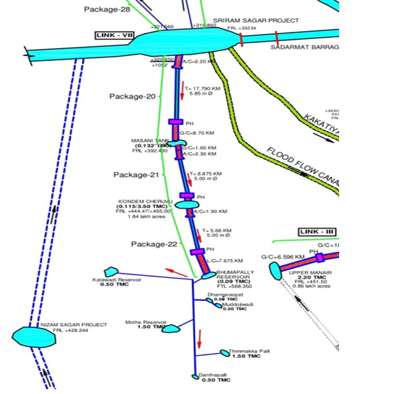
which conveys water to a series of reservoirs, canals, and tunnel systems in Package 20, 21 & 22, and irrigates ayacut under Nizamabad and Kamareddy districts. The second off-take for this link is from SRSP foreshore and conveys water to irrigate ayacut in Nirmal district under Package 27. The third off-take is also from the SRSP foreshore and creates ayacut in Nirmal district under Package 28.
The total length of the link includes a tunnel of 56 km, gravity canal of 285 km, and pressure main of 55 km length. The total length of the conveyor system of Link VII is about 395 KM.

Project Benefits
Kaleshwaram Lift Irrigation Scheme of Telangana is one of the world’s biggest irrigation project that is set to end water woes of the state where many regions are parched. This project aims at an ambitious target of diverting 195 TMC of water to the backward areas in the state of Telangana. The project envisages the following:
-
Diversion of 195 TMC of Godavari water to Sripada Rao Yellampally project and subsequently to Mid Manair Reservoir by lifting it to the lands on higher contour which is found to be economically viable, to bring large extents of lands in the basin under irrigation.
-
To Create an additional ayacut of about 18.25 lakhs acres in Adilabad, Karimnagar, Medak, Nalgonda, Nizamabad and Ranga Reddy districts including 40 TMC of drinking water to several towns and cities of the state, especially the most important twin cities of Hyderabad and Secunderabad and en route villages and 16 TMC of water for Industrial use and 18.82 Lakh acres of stabilization ayacut.
-
To stabilize shortfalls in planned utilization, under SRSP Stage-I & Stage-II, Flood Flow Canal, Singur project and Nizam Sagar project.
-
To restore the ground water level to its original state by the way of shifting from usage of groundwater for irrigation to usage of surface water and conjunctive use of groundwater for the same.