
The Northern Plains
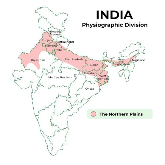 The Northern Plains of India are a vast and fertile region formed by the alluvial deposits of the Indus, Ganga, and Brahmaputra rivers. Stretching approximately 3,200 km from east to west and varying in width between 150-300 km, these plains are a crucial agricultural and ecological zone.
Formation and Characteristics
Alluvial Deposits:
-
- Source: Deposited by the Indus, Ganga, and Brahmaputra rivers.
- Depth: The maximum depth of these deposits ranges from 1,000 to 2,000 meters.
General Elevation:
-
- Elevation: Generally 50-150 meters above mean sea level.
- Features: Characterized by a relatively flat terrain with some variations due to fluvial processes.
Major Zones of the Northern Plains
Bhabar:
-
- Location: A narrow belt, approximately 8-10 km wide, located parallel to the Shivalik foothills.
- Features: The region where rivers and streams deposit heavy materials such as rocks and boulders, resulting in a porous and gravelly area. Streams often disappear or become less visible due to rapid infiltration.
Tarai:
-
- Location: Lies south of the Bhabar zone, with a width of about 10-20 km.
- Features: Known for its marshy and swampy conditions created by streams and rivers re-emerging without well-defined channels. It supports lush vegetation and a diverse range of wildlife, making it an ecologically rich area.
Alluvial Plains:
-
- Sub-divisions:
- Khadar: Represents the newer alluvial deposits found in the floodplains. These are areas of active sedimentation and often have fertile soil.
- Bhangar: Comprises older alluvial deposits, characterized by more mature and stable landforms. The soil is typically less fertile compared to Khadar due to its age and sedimentary history.
- Sub-divisions:
Physiographic Features
Fluvial Landforms:
-
- Sand Bars: Formed by the deposition of sediment in river channels.
- Meanders: Curved river paths formed due to sediment deposition and erosion processes.
- Ox-Bow Lakes: Crescent-shaped lakes formed when a meander becomes isolated from the main river channel.
- Braided Channels: Formed by multiple channels splitting and rejoining due to high sediment loads and variable flow conditions.
Brahmaputra Plains:
Noted for its riverine islands and sandbars. The region frequently experiences flooding and shifting river courses, contributing to the formation of braided streams.
River Deltas
Sunderbans Delta:
-
- Location: Formed by the confluence of the Ganges, Brahmaputra, and their tributaries.
- Features: One of the largest and most famous deltas in the world. It is characterized by a complex network of rivers, tidal waterways, mudflats, and mangroves.
Water Divides and River Flow
Haryana and Delhi:
- These states form a water divide between the Indus and Ganga river systems, influencing the direction and distribution of river waters in northern India.
Brahmaputra River:
- Originates in Tibet, flows southeast through India, and takes a sharp 90° turn southward at Dhubri before entering Bangladesh.
Agricultural Significance
- Soil: The alluvial soil in these plains is highly fertile, supporting a variety of crops.
- Crops: Includes wheat, rice, sugarcane, and jute. The fertile soil supports a large and dense population due to its high agricultural productivity.
