
Drainage System of India
- Drainage Definition: Drainage refers to the process of removing excess water from the surface or subsurface of a particular area. It plays a crucial role in managing water resources, preventing flooding, and maintaining soil fertility in both urban and rural settings.
- Drainage System: A drainage system refers to a network of pipes, channels, or natural land formations designed to direct excess water away from land surfaces or sub surfaces to prevent flooding, waterlogging, and soil erosion. Drainage systems are essential in both urban and rural areas, as they contribute to water management, agricultural productivity, and environmental sustainability.
Factors Influencing Drainage System:
- Geological Time Period: The geological history of an area, including tectonic movements and erosion over millions of years, shapes the drainage patterns. Older rivers develop more extensive networks, while younger ones are less complex.
- Nature and Structure of Rocks: The type of rock, whether hard or soft, affects water flow. Hard rocks resist erosion, forming fewer channels, while soft, porous rocks lead to more intricate drainage systems. Faults and fractures also guide water flow.
- Slope and Topography: Steep slopes result in rapid water runoff and straight rivers, while gentle slopes allow slower, meandering streams. Topography, such as mountains or plains, defines the direction and extent of water flow.
- Amount of Water Flowing: The volume of water (discharge) influences the size and shape of drainage networks. High-flow rivers carve broad valleys, while low-flow streams may create intermittent channels. Rainfall, snowmelt, and human activities also affect water flow.
- Periodicity of Flow: Perennial rivers have permanent channels, while seasonal or ephemeral streams, which flow only during certain times, create temporary or unstable drainage patterns.
Drainage Basin:
A drainage basin, also known as a watershed or catchment area, is a geographical region where all precipitation and surface water flow converge to a single point, typically a river, lake, or ocean. The boundary of a drainage basin is defined by a drainage divide, which separates it from adjacent basins.
Water Divide:
A water divide, also known as a drainage divide or watershed divide, is an elevated area such as a mountain range, ridge, or upland that separates two adjacent drainage basins. Water on either side of the divide flows into different drainage systems, ensuring that the water from one basin does not mix with water from another.
Largest Drainage Basins:
-
- World: Amazon River Basin.
- India: Ganga River Basin.
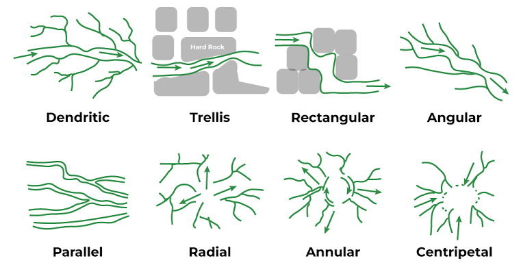
Different Drainage Patterns
- Dendritic – A drainage pattern that resembles the branching of a tree is called dendritic. An example of this is the river systems in the northern plains.
- Radial – In a radial drainage pattern, rivers flow outward in all directions from a central point, typically a hill or elevated area. The rivers originating from the Amarkantak range are a prime example.
- Trellis – The trellis drainage pattern occurs when primary tributaries run parallel to each other, and secondary tributaries meet them at right angles.
- Centripetal – In a centripetal pattern, rivers converge from all directions and discharge their water into a central lake or depression.