
The Indus River System
Overview:
- Total Basin Area: 11,65,000 sq km
- Area in India: 3,21,289 sq km
- Total Length: 2,880 km
- Length in India: 1,114 km
- Alternate Name: Sindhu
- Location: Westernmost of the Himalayan rivers in India
Origin and Course:
Origin:
- Source: Glacier near Bokhar Chu, Kailash Range, Tibetan region
- Coordinates: 31°15′ N latitude and 81°41′ E longitude
- Altitude: 4,164 m
Course:
- In Tibet: Known as “SingiKhamban” or “Lion’s Mouth”
- In India: Enters Ladakh (Leh) and forms a picturesque gorge
- Himalayan Tributaries: Shyok, Gilgit, Zaskar, Hunza, Nubra
- Major Region: Flows through Baltistan and Gilgit
- Emergence from Mountains: Attock, where it receives the Kabul River on its right bank
- Flow Through Pakistan:
- Flows southwards to Panjnad near Mithankot
- Panjnad River: Confluence of the Satluj, Beas, Ravi, Chenab, and Jhelum
- Final Destination: Arabian Sea
Key Points:
- Geography: The Indus River originates from the Tibetan Plateau, flowing through the Ladakh region in India and eventually traversing Pakistan before reaching the Arabian Sea.
- Gorge Formation: Notable for its deep gorge in Ladakh, adding to its scenic beauty.
- Confluence: The Panjnad River is the meeting point for the major five rivers (Satluj, Beas, Ravi, Chenab, and Jhelum), which are critical to the river system.
- Historical Significance:
- Cultural and Historical: The Indus River is one of the world’s oldest and most historically significant rivers, essential to the Indus Valley Civilization.
- Economic Importance: The river basin is vital for agriculture and irrigation in both India and Pakistan.
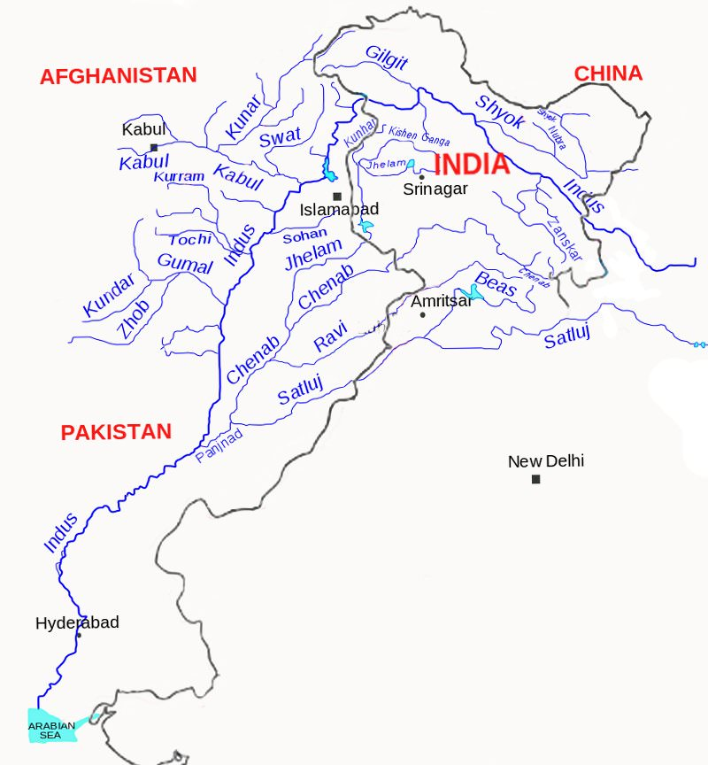
Main Tributaries of Indus River
| Satluj |
|
| Beas |
|
| Ravi |
|
| Chenab |
|
| Jhelum |
|
Right and Left bank tributaries of the Indus River
Right bank tributaries
Major right bank tributaries include the Nubra River (the main tributary of the Shyok River), Shyok River, Gilgit River, Hunza River, Kabul River, Khurram River, Gomal River, Viboa River, Tochi River, and Sangar River.
Left bank tributaries
The left bank tributaries consist of the Zanskar River, Suru River, Kishanganga (Neelam) River, Jhelum River, Chenab River, Ravi River, Beas River, Satluj River, and Panjnad River.
Indus Water Treaty (IWT)
Overview:
- Date Signed: September 19, 1960
- Signatories: India and Pakistan
- Purpose: To address and manage the allocation of water from the Indus River System between the two countries.
Context:
- The treaty was established in the aftermath of the 1947 Partition, which had raised concerns about the equitable sharing of the Indus River System’s waters.
- It was brokered by the World Bank to help resolve disputes over water usage and to foster cooperation between India and Pakistan.
Key Provisions:
Division of Rivers:
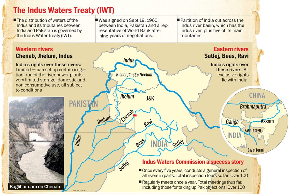
- Eastern Rivers: Satluj, Beas, Ravi
- Western Rivers: Chenab, Jhelum, Indus
Water Allocation:
- India: Granted rights to the waters of the eastern rivers (Satluj, Beas, and Ravi).
- Pakistan: Granted rights to the waters of the western rivers (Chenab, Jhelum, and Indus).
Water Usage:
- India can use the waters of the eastern rivers for irrigation, power generation, and other purposes, with certain restrictions on storage and diversion.
- Pakistan has the right to use the waters of the western rivers for irrigation, agriculture, and other uses.
- Dispute Resolution: The treaty established the Permanent Indus Commission, which is tasked with overseeing the implementation of the treaty, resolving disputes, and promoting cooperation between the two countries.
- Development Fund: The Indus Basin Development Fund was created to finance projects that would help in the development and management of the water resources in the basin, particularly for Pakistan’s benefit.
Implementation:
Permanent Indus Commission:
- Consists of representatives from both India and Pakistan.
- Responsible for overseeing and managing water resources and ensuring compliance with the treaty.
Indus Basin Development Fund:
Established to support infrastructure development and manage the river system effectively.
Significance:
- Strategic Importance: The treaty is crucial for managing the water resources of the Indus River System, which is essential for agriculture and the livelihoods of people in both countries.
- Diplomatic Relations: It represents a significant diplomatic achievement in the context of the complex and often strained relations between India and Pakistan.
- Environmental Impact: Helps in regulating water usage and addressing the environmental impacts of water resource management.
Challenges:
- Disputes: There have been periodic disputes and tensions related to water allocation and infrastructure projects, such as dam construction.
- Political Tensions: Changes in political dynamics and regional conflicts have sometimes affected the implementation and management of the treaty.
