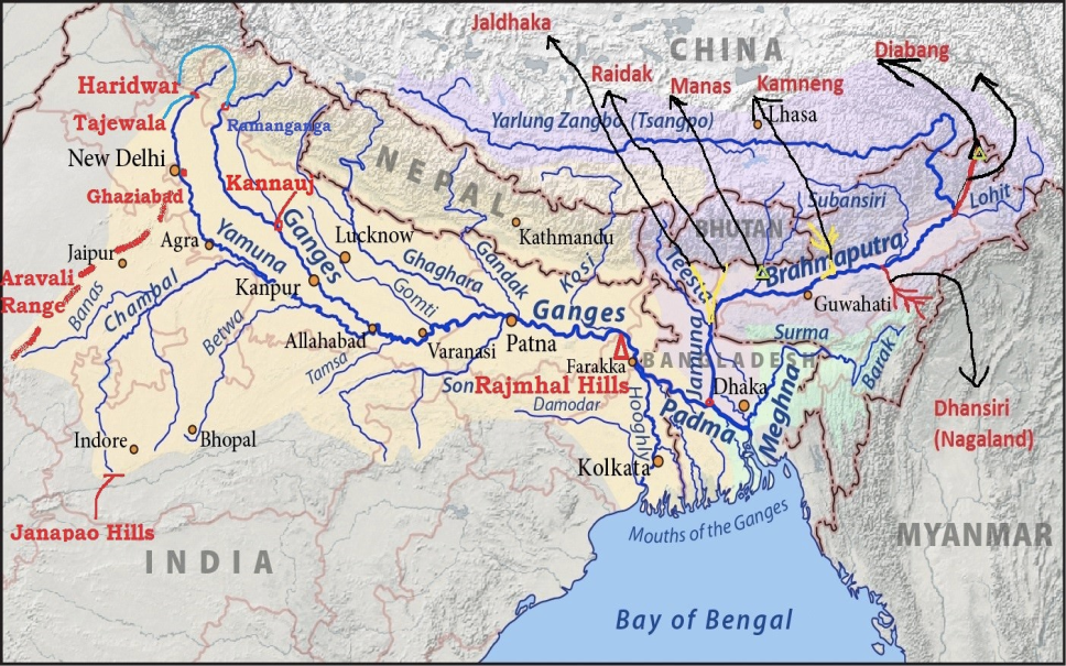

The Brahmaputra River System
Overview:
- Type: Transboundary river system
- Countries: China, India, Bangladesh
- Length: Approximately 2,900 km
Origin:
- Source: Chemayungdung Glacier, Kailash Range near Mansarovar Lake
- Tibetan Name: Tsangpo (meaning “the purifier”)
- Major Tibetan Tributary: Rango Tsangpo
Course:
- In Tibet: Flows eastward across southern Tibet, carving a deep gorge near Namcha Barwa (7,755 m)
- In India:
- Name: Siang or Dihang upon entering Arunachal Pradesh
- Flow: Flows southwest through Arunachal Pradesh, Assam, and then continues into Bangladesh
- Tributaries: Receives major left-bank tributaries like Dibang (Sikang) and Lohit, becoming known as Brahmaputra in Assam
- In Bangladesh:
- Name: Known as Jamuna after receiving the Tista/Teesta River from Sikkim
- Branches:
- Western Branch: Continues as Jamuna and merges with the Padma River (Ganga)
- Eastern Branch: Known as the lower or old Brahmaputra, merges with the Meghna River near Dhaka
Confluence and Delta:
Convergence Points:
-
- Padma and Meghna Rivers: Merge near Chandpur
- Final Discharge: Flows out into the Bay of Bengal as Meghna River
Tributaries:
- Left-Bank Tributaries:Burhi-Dihing, Dhansiri
- Right-Bank Tributaries:Subansiri (Gold River), Kameng, Manas, Sankosh
Unique Features:
- Braided Channel: The Brahmaputra maintains a braided channel along its entire length in Assam, forming many riverine islands.
- Largest River Island: Majuli, located in Assam, is the largest river island in the world.
- Flooding and Erosion: The river is prone to flooding, channel shifting, and bank erosion due to its large sediment load from heavy rainfall in its catchment area.