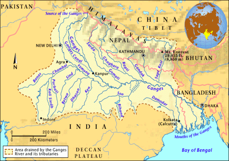
The Ganga River System
Overview:
- Type: Transboundary river system
- Countries: India, Bangladesh
- Length: Approximately 2,525 km
- Basin Area: About 8.6 lakh sq km in India
Origin:
- Source: Gangotri Glacier near Gaumukh, Uttarakhand
- Initial Name: Bhagirathi
- Confluence: Meets Alaknanda at Devprayag to become the Ganga
Major Tributaries and Confluences:
Alaknanda:
- Source: Satopanth Glacier above Badrinath
- Panch Prayag (Five Confluences):
- Vishnuprayag: Confluence of Dhauliganga and Alaknanda
- Nandaprayag: Confluence of Mandakini and Alaknanda
- Karnaprayag: Confluence of Pindar and Alaknanda
- Rudraprayag: Confluence of Mandakini and Alaknanda
- Devprayag: Confluence of Bhagirathi and Alaknanda
Course Through India:
- Uttarakhand: Flows 110 km
- Uttar Pradesh: Flows 1,450 km
- Bihar: Flows 445 km
- West Bengal: Flows 520 km
Flow Path:
- Initial Flow: Flows southwards, then southeast towards Mirzapur
- Eastern Flow: Continues eastwards in the Bihar plains
- Farakka, West Bengal:The distributary flows southwards as the Bhagirathi-Hooghly, eventually reaching the Bay of Bengal near Sagar Island.
Course Through Bangladesh:
- Main Branch: Referred to as the Padma River
- Confluence: Merges with the Jamuna River, the largest distributary of the Brahmaputra
- Further Confluence: Later joins the Meghna River, the second largest distributary of the Brahmaputra
- Delta:Sundarban Delta, world’s largest and fastest-growing delta; habitat of the Royal Bengal Tiger
Key Points:
- Haridwar: Transition from mountains to plains
- Flooding and Sedimentation: Known for its seasonal flooding and high sediment load
Right Bank Tributaries
| Yamuna River |
|
| Tamas River |
|
| Son/Sone River |
|
| Punpun River |
|
Left Bank Tributaries
| Ramganga
River |
|
| Gomti River |
|
| Ghaghara River |
|
| Gandhak River |
|
| Kosi River |
|
| Mahananda River |
|