Why in News?
The Centre is considering a phased notification of Ecologically Sensitive Areas in the Western Ghats, beginning with States where agreement on boundaries is close, particularly Gujarat, Maharashtra and Goa.
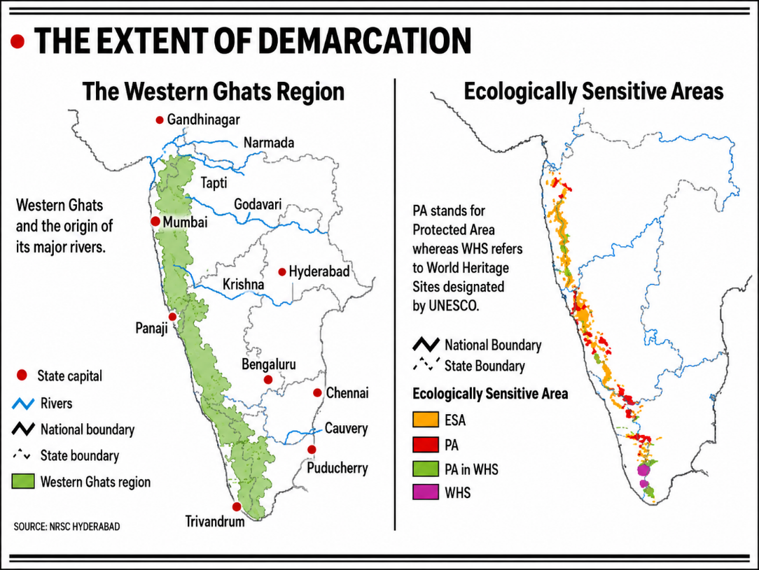
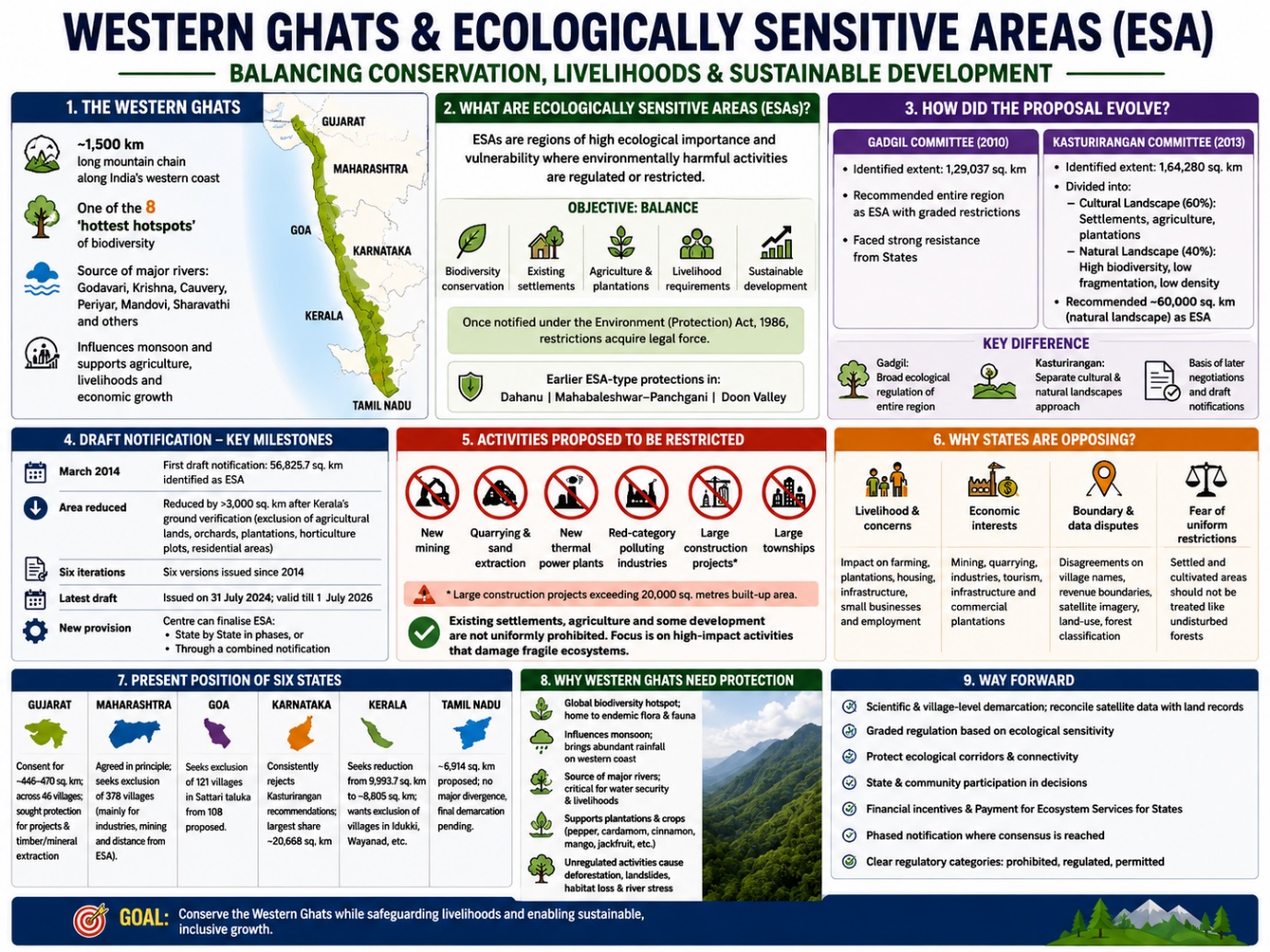
The latest draft notification proposes to designate 56,825.7 sq. km across six States as ESA. However, disagreements over village boundaries, agricultural areas, plantations, industries, mining and development restrictions have prevented final notification for more than a decade.
The six concerned States are:
- Gujarat
- Maharashtra
- Goa
- Karnataka
- Kerala
- Tamil Nadu
What are Ecologically Sensitive Areas?
Ecologically Sensitive Areas are regions of high ecological importance and vulnerability where environmentally harmful activities are regulated or restricted.
The objective is not necessarily to prohibit all human activity, but to balance:
- Biodiversity conservation
- Existing settlements
- Agriculture and plantations
- Livelihood requirements
- Sustainable development
Once notified under the Environment (Protection) Act, 1986, the restrictions acquire legal force.
Earlier ESA-type protections have been applied in areas such as:
- Dahanu
- Mahabaleshwar–Panchgani
- Doon Valley
How Did the Western Ghats ESA Proposal Evolve?
Gadgil Committee
- The Madhav Gadgil-led Western Ghats Ecology Expert Panel, constituted in 2010, identified the Western Ghats as covering about 1,29,037 sq. km.
- It recommended that the entire region be treated as ecologically sensitive, with restrictions based on the degree of ecological fragility.
- The proposal faced strong resistance from States because of concerns over extensive restrictions on economic and developmental activities.
Kasturirangan Committee
A High-Level Working Group chaired by former ISRO Chairman K. Kasturirangan was subsequently constituted.
Its 2013 report identified the geographical extent of the Western Ghats as approximately 1,64,280 sq. km and divided it into:
- Cultural Landscape — 60%: Settlements, agriculture and plantations dominated by human activity.
- Natural Landscape — 40%: Regions with high biodiversity, low fragmentation and low population density, including national parks and tiger and elephant habitats.
The Committee proposed that around 60,000 sq. km of natural landscape be designated as ESA.
How Did the Gadgil and Kasturirangan Approaches Differ?
| Aspect | Gadgil Committee | Kasturirangan Committee |
| Identified extent | 1,29,037 sq. km | 1,64,280 sq. km |
| Proposed coverage | Entire Western Ghats | Mainly natural landscape |
| Approach | Broad ecological regulation | Separation of cultural and natural landscapes |
| Approximate ESA | Entire identified region with graded restrictions | Around 60,000 sq. km |
| State response | Strong resistance | Basis of later negotiations and draft notifications |
The Kasturirangan approach attempted to reduce the impact on settlements, plantations and agricultural areas while protecting relatively undisturbed ecosystems.
How Did the Draft Notification Evolve?
The recommendations were accepted in principle, but States were invited to submit their objections before finalising the boundaries.
In March 2014, the Centre issued the first draft notification identifying 56,825.7 sq. km as ESA.
The area was reduced by more than 3,000 sq. km after Kerala conducted a ground-verification exercise and sought the exclusion of:
- Agricultural lands
- Orchards
- Horticultural plots
- Plantations
- Residential areas
Six versions of the draft notification have been issued since 2014. The latest was issued on July 31, 2024, and remains valid until late July 2026.
A significant change in the latest draft allows the Centre to finalise the ESA:
- State by State in phases, or
- Through a combined notification covering all six States
What Activities Would be Restricted?
The proposed framework seeks to prohibit or tightly regulate activities with a major ecological impact, including:
- New mining
- Quarrying and sand extraction
- New thermal power plants
- Red-category polluting industries
- Large construction projects
- Large townships
The supplied proposal also refers to restrictions on large construction projects exceeding a built-up area of 20,000 sq. metres.
Existing settlements, agriculture and some forms of development are not intended to be uniformly prohibited. The regulatory focus is primarily on high-impact activities that may fragment or damage fragile ecosystems.
Why are States Opposing the Proposal?
Livelihood and Settlement Concerns
The Western Ghats are densely populated, unlike many remote mountain ecosystems. Numerous villages, farms and plantations fall close to the proposed ESA boundaries.
States fear that restrictions may affect:
- Farming
- Plantation activities
- Housing
- Local infrastructure
- Small businesses
- Employment
Economic Interests
The region supports:
- Mining
- Quarrying
- Industries
- Tourism
- Infrastructure projects
- Commercial plantations
Some States have sought exclusions to preserve space for these activities.
Boundary and Data Disputes
Disagreements remain over:
- Village names
- Revenue boundaries
- Satellite imagery
- Land-use classification
- Forest and non-forest areas
- Differences between official records and ground conditions
Fear of Uniform Restrictions
States argue that villages with settlements and agricultural activity should not be treated in the same way as undisturbed forests or wildlife habitats.
What is the Present Position of the Six States?
Gujarat
- Gujarat has reportedly given final consent for approximately 449–470 sq. km across 64 villages. It has sought protection for ongoing projects and limited minor-mineral extraction in non-forest areas.
Maharashtra
- Maharashtra has agreed in principle but has sought the exclusion of 378 villages, citing industries, mining and the distance of some villages from ecologically sensitive zones.
- The supplied reports give different totals for the number of villages initially identified, but both agree on the demand to exclude 378 villages.
Goa
- Goa has sought the exclusion of 21 villages in Sattari taluka from the 108 villages proposed under ESA.
Tamil Nadu
- Tamil Nadu has about 6,914 sq. km proposed under ESA and has not raised major divergences, although final demarcation remains pending.
Karnataka
- Karnataka has the largest proposed ESA share, around 20,668 sq. km, but has consistently rejected the Kasturirangan recommendations.
Kerala
- Kerala has sought to reduce its proposed ESA from 9,993.7 sq. km to around 8,805 sq. km.
It has demanded the exclusion of villages in areas such as:
- Idukki
- Wayanad
- Cardamom Hills
The State argues that these regions contain plantations, agriculture and settlements. The expert committee has not accepted all the proposed exclusions.
Why Do the Western Ghats Need Protection?
Global Biodiversity Importance
- The Western Ghats are one of the world’s recognised biodiversity hotspots and are counted among the eight hottest hotspots of biological diversity.
- They support hundreds of plants and animals found nowhere else.
Influence on the Monsoon
- The mountain chain acts as a physical barrier to moisture-bearing winds, producing abundant rainfall on its western coastal side.
Source of Major Rivers
Its forests, springs and rainfall sustain important rivers, including:
- Godavari
- Krishna
- Cauvery
- Periyar
- Mandovi
- Sharavathi
These river systems support water security, agriculture, livelihoods and economic activity across peninsular India.
Ecological Continuity
- Mining, deforestation, habitat loss and unregulated construction can fragment wildlife habitats and disrupt ecological corridors.
Disaster Vulnerability
- Concerns over landslides, deforestation and uncontrolled construction have increased the demand for stronger environmental regulation.
Livelihood Dependence
The region has historically supported plantations and cultivation of:
- Pepper
- Cardamom
- Cinnamon
- Mango
- Jackfruit
Its conservation is therefore connected not only with wildlife but also with long-term livelihood and water security.
What is the Centre’s Phased Plan?
The Centre is considering moving ahead with ESA notifications in States where consensus is close instead of waiting for agreement from all six States.
The first phase may include:
- Gujarat
- Maharashtra
- Goa
This phased approach seeks to prevent disputes in Karnataka and Kerala from indefinitely delaying legal protection in States where boundaries are largely settled.
What is the Role of the 2022 Expert Committee?
The Centre constituted a fresh expert committee in 2022 under Sanjay Kumar, former Director General of Forests.
The Committee has:
- Held meetings with State governments
- Conducted field visits in all concerned States except Kerala
- Examined satellite imagery
- Reconciled village-level records
- Reviewed revenue and boundary details
- Considered State objections
- Studied the continuity of ecological corridors
The Committee includes experts associated with institutions such as:
- Indian Institute of Science
- Indian Institute of Remote Sensing
- Geological Survey of India
Its final report will determine whether the additional reductions sought by States should be accepted.
Can Financial Incentives Improve State Cooperation?
The expert committee has considered financial incentives for States that protect the Western Ghats.
The Kasturirangan Committee had recommended that the six States negotiate with the Centre for grant-in-aid in return for conserving natural resources.
It also suggested arrangements for Payment for Ecosystem Services, recognising benefits such as:
- Water security
- Forest conservation
- Biodiversity protection
- Climate regulation
- Ecological services extending beyond State boundaries
Such financial support could help compensate States and local communities for restrictions on revenue-generating activities.
Way Forward
Scientific and Village-Level Demarcation
- Satellite imagery must be reconciled with land records and field verification to prevent settlements and agricultural areas from being wrongly classified.
Graded Regulation
- Restrictions should be based on ecological sensitivity rather than applying identical rules to forests, plantations and densely populated villages.
State and Community Participation
- State governments, local bodies, farmers, plantation workers and civil society should participate in finalising boundaries and regulatory conditions.
Protect Ecological Corridors
- Exclusions should not break the continuity of forests, wildlife habitats and river catchments.
Compensate Conservation
- Grant-in-aid and Payment for Ecosystem Services can reduce the financial burden of protecting ecologically valuable regions.
Adopt Phased Notification
- States where consensus has been achieved should not be forced to wait indefinitely for unresolved disputes elsewhere.
Ensure Regulatory Clarity
- The final notification should clearly distinguish between prohibited activities, regulated activities and activities that may continue.
Conclusion
The Western Ghats ESA debate represents a difficult balance between ecological security, local livelihoods and State development priorities. The region’s biodiversity, monsoon influence and role in sustaining major rivers make conservation essential, but its dense population and plantation economy require a carefully differentiated approach.
A scientifically demarcated, consultative and phased framework—supported by financial compensation and graded restrictions—can protect the Western Ghats without treating conservation and development as mutually exclusive goals.