

Why in News?
- India’s 51st Doppler Weather Radar was inaugurated at Sambalpur in Odisha on September 17, 2026. It will strengthen weather monitoring and early warnings across western Odisha and parts of neighbouring States. With this commissioning, Odisha now has three DWRs—at Sambalpur, Gopalpur and Paradip. India plans to install 40 more radars under Mission Mausam.
What is a Doppler Weather Radar?
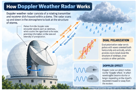
A Doppler Weather Radar is a remote-sensing instrument used to detect precipitation and measure the movement of weather systems.
Unlike an ordinary radar, which mainly locates an object, a DWR provides information about both:
- The position and distance of atmospheric targets such as raindrops; and
- Their direction and speed of movement towards or away from the radar.
This makes DWRs particularly valuable for tracking thunderstorms, cyclones, cloud bands and intense rainfall.
What is the Doppler Effect?
- The Doppler Effect refers to the apparent change in the frequency of a wave when there is relative movement between its source and the observer.
- For example, the whistle of an approaching train appears to have a higher pitch because the sound waves are compressed. As the train moves away, the waves stretch and the pitch becomes lower.
- Doppler Weather Radars apply the same principle to reflected radio waves. The phenomenon is named after Christian Doppler, a 19th-century Austrian physicist.
How Does a Doppler Weather Radar Work?
A radar antenna transmits short pulses of radio waves into the atmosphere. When these waves encounter raindrops, ice particles, hailstones or clouds, part of their energy is scattered back towards the radar.
The returned signal provides the following information:
- Size and intensity: Larger or denser targets return more energy, helping estimate precipitation intensity.
- Distance: The time taken by a radio pulse to travel to the target and return indicates its distance from the radar.
- Direction of movement: A change in the phase or frequency of the returned signal reveals whether precipitation is moving towards or away from the radar.
- Speed: The size of the phase shift helps calculate the radial velocity of the target.
Radar observations are updated approximately every 10 minutes, enabling forecasters to monitor the formation, direction and changing intensity of weather systems almost in real time.
According to the US National Weather Service, a DWR transmits signals for only a little over seven seconds in an hour and spends the remaining 59 minutes and 53 seconds receiving and analysing returned signals.
Types of Doppler Weather Radars Used in India
The India Meteorological Department (IMD) commonly uses three frequency bands:
| Radar band | Major application |
| X-band | Detection of localised thunderstorms and lightning-producing systems |
| C-band | Monitoring rainfall and tracking cyclonic systems |
| S-band | Deep coastal surveillance and long-range cyclone monitoring |
Together, these radars track cloud bands and weather systems and estimate rainfall over a coverage area of about 500 km, depending on radar type and atmospheric conditions.
Why are Doppler Weather Radars Important?
Accurate Weather Monitoring
- DWRs provide high-resolution information on the location, movement and intensity of precipitation. This improves nowcasting, or very short-range forecasting of rapidly developing weather.
Early Warning of Extreme Events
They help identify and track:
- Cyclones and associated rainfall
- Thunderstorms
- Lightning-producing systems
- Cloudbursts and intense rainfall
- Hailstorms
- Sudden changes in wind patterns
Disaster-Risk Reduction
- Timely radar information enables governments to issue warnings, evacuate vulnerable populations and prepare emergency services before hazardous weather reaches populated areas.
Sectoral Benefits
Reliable forecasts support decision-making in:
- Agriculture: Crop planning, irrigation and harvesting
- Aviation: Safer flight operations
- Defence: Operational planning
- Water resources: Reservoir and flood management
- Energy: Demand and renewable-energy forecasting
- Urban governance: Drainage and transport management
- Tourism and fisheries: Weather-based safety advisories
Sambalpur Doppler Weather Radar
The commissioning of the radar at Sambalpur expands India’s meteorological observation infrastructure.
Its principal benefits include:
- Improved monitoring of thunderstorms, lightning and heavy rainfall in western Odisha.
- Better meteorological data for adjoining areas of southern Jharkhand, northern Chhattisgarh, northern Andhra Pradesh and West Bengal.
- Stronger regional early-warning systems in areas vulnerable to extreme weather.
- Improved coordination between weather agencies and disaster-management authorities.
With Sambalpur, the national DWR network has increased to 51 radars.
Mission Mausam
About the Mission
- Mission Mausam was launched on January 14, 2025, during celebrations marking the 150th foundation day of the India Meteorological Department.
- The Union Cabinet had approved the Mission in September 2024 with an allocation of ₹2,000 crore for two years. Its broader objective is to make India a “weather-ready” and “climate-smart” nation.
Implementing Institutions
The Mission is primarily implemented by three institutions under the Ministry of Earth Sciences:
- India Meteorological Department
- Indian Institute of Tropical Meteorology
- National Centre for Medium-Range Weather Forecasting
They are supported by other institutions, including:
- Indian National Centre for Ocean Information Services
- National Centre for Polar and Ocean Research
- National Institute of Ocean Technology
Major Components
Mission Mausam provides for:
- Deployment of next-generation radars and satellite systems with advanced sensors.
- Installation of 40 additional Doppler Weather Radars.
- Use of high-performance supercomputers.
- Development of improved Earth-system and weather models.
- A GIS-based automated decision-support system for real-time data sharing.
- Expansion of research and capacity in atmospheric sciences, weather surveillance, forecasting and weather management.
Areas Covered
The Mission seeks to improve forecasts relating to:
- Monsoon behaviour
- Cyclones and extreme weather
- Air quality
- Rainfall, hail, fog and lightning
- Weather and climate information across different spatial and temporal scales
It also seeks to strengthen research into weather interventions, including the possibility of enhancing or suppressing rainfall, hail and fog under suitable conditions.
Significance for India
India is highly vulnerable to cyclones, floods, lightning, heatwaves and extreme rainfall. Rapid urbanisation and climate change have increased the exposure of people, infrastructure and economic activity to such events.
An expanded DWR network under Mission Mausam can:
- Reduce the loss of life through timely warnings.
- Improve location-specific forecasts.
- strengthen preparedness among States and local bodies.
- Support climate-resilient agriculture and infrastructure.
- Enable real-time sharing of weather information.
- Improve the delivery of warnings to citizens and last-mile users.
Thus, weather radars are not merely scientific instruments; they form a vital part of India’s disaster-management and climate-adaptation infrastructure.
Challenges
- Gaps in Radar Coverage: Mountainous, coastal and remote regions may not receive uniform radar coverage, reducing the accuracy of local forecasts.
- Terrain-Related Limitations: Hills, buildings and other physical barriers can block radar signals and create observation gaps.
- High Installation and Maintenance Costs: Doppler Weather Radars require significant investment, regular calibration, technical maintenance and uninterrupted power supply.
- Shortage of Skilled Personnel: Trained meteorologists, radar engineers and data scientists are needed to interpret large volumes of weather data accurately.
- Integration of Weather Data: Radar information must be effectively combined with data from satellites, ocean buoys, automatic weather stations and ground observatories.
- Forecasting Localised Events: Sudden cloudbursts, lightning and small-scale thunderstorms can develop rapidly, making precise prediction difficult.
- Last-Mile Communication Gaps: Accurate forecasts may not save lives if warnings fail to reach farmers, fishers, local authorities and vulnerable communities on time.
- Impact of Climate Change: Changing rainfall patterns and increasing extreme-weather events make weather prediction more complex.
Way Forward
- Expand the Radar Network: Install the proposed Doppler Weather Radars under Mission Mausam, with priority given to disaster-prone and poorly covered regions.
- Adopt Multi-Source Forecasting: Integrate radar, satellite, oceanic and ground-based observations to improve forecast accuracy.
- Strengthen Technical Capacity: Train more meteorologists, engineers and data specialists in radar operation, maintenance and weather modelling.
- Improve Impact-Based Forecasting: Warnings should explain not only the expected weather event but also its likely effects on people, agriculture, transport and infrastructure.
- Ensure Last-Mile Connectivity: Disseminate alerts through mobile applications, SMS, local administrations, community radio and regional-language communication networks.
- Promote Institutional Coordination: Strengthen coordination among the IMD, disaster-management authorities, State governments and local bodies.
- Use Advanced Technologies: Apply artificial intelligence, high-performance computing, GIS and improved Earth-system models for faster and more location-specific forecasting.
- Regularly Evaluate Warning Systems: Conduct periodic reviews to assess whether forecasts are timely, accurate and accessible to vulnerable communities.
Conclusion
The Sambalpur Doppler Weather Radar represents an important expansion of India’s weather-observation network. Combined with Mission Mausam, it can strengthen forecasting, disaster preparedness and climate-resilient planning. However, technological capability must be supported by reliable maintenance, institutional coordination and effective last-mile communication. A comprehensive early-warning system will help protect lives, livelihoods and infrastructure while advancing climate-smart governance.
Why in News?
India has started exporting Hilsa fish to Bangladesh, reversing the traditional trade pattern under which Bangladesh supplied Hilsa to India.Around 500 tonnes of Hilsa were exported to Bangladesh through the Petrapole Land Port in West Bengal during the previous two months. Traders expect another 150–200 tonnes to be exported in the coming weeks.
What is Hilsa?
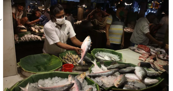
Hilsa, popularly known as Ilish in Bengali, belongs to the Clupeidae family, which also includes herring fish.
It is highly valued for its:
- Delicate flavour
- Distinctive taste
- Soft and oily texture
- Nutritional value
Hilsa has a silvery and relatively flat body, a pointed head and numerous small bones.
Two important species found in the Bay of Bengal region are:
- Tenualosa ilisha
- Tenualosa toli
Hilsa is the State Fish of West Bengal and the National Fish of Bangladesh. Bangladesh produces nearly 70% of the world’s Hilsa.
The fish is classified as Least Concern on the IUCN Red List. However, local populations may still decline because of overfishing and habitat degradation.
Habitat and Distribution
Hilsa lives in both marine and freshwater environments. It is found in rivers, estuaries and coastal waters of:
- India
- Bangladesh
- Pakistan
- Myanmar
- Persian Gulf region
Major river systems associated with Hilsa include:
- Padma and Meghna in Bangladesh
- Hooghly-Bhagirathi, Ganga and Godavari in India
The Bay of Bengal provides an important marine habitat for the species.
Migratory and Breeding Pattern
- Hilsa is an anadromous fish. This means that it spends most of its adult life in the sea but migrates into freshwater rivers for breeding and spawning.
- Its major breeding migrations take place during:
- Mid-February to April
- September to October
- Hilsa may be caught throughout the year, but the monsoon is its peak fishing season. Strong river flows during this period support its upstream movement.
- Therefore, the survival of Hilsa depends on continuous ecological connectivity between the sea, estuaries and rivers.
Cultural and Economic Importance
- Hilsa occupies an important place in the traditions of Bengali communities in India and Bangladesh.
Ilish Utsab
- West Bengal celebrates Ilish Utsab, during which restaurants and households prepare different Hilsa dishes.
Joda Ilish
- A pair of Hilsa fish is called Joda Ilish. It symbolises harmony, prosperity and good fortune and is associated with weddings and festivals.
Livelihood Importance
- Hilsa supports the livelihoods of fishers, traders, transporters, wholesalers and food-processing enterprises. Its high market value makes it economically important for coastal and riverine communities.
Traditional Hilsa Trade
- Traditionally, India imported Hilsa from Bangladesh, especially during the Durga Puja season.
- Bangladesh began restricting Hilsa exports in 2012 to protect domestic stocks and maintain local availability.
- Since 2019, Bangladesh has generally permitted exports to India for a limited period of about one month during Durga Puja.
However, actual imports have remained much lower than the permitted quantities.
| Period | Quantity permitted | Quantity actually imported |
| September 2024 | 2,420 tonnes | 577 tonnes |
| September 2025 | 1,200 tonnes | 150 tonnes |
The short permission period creates difficulties in procurement, transportation and marketing. Bangladesh has currently paused its Hilsa exports to India.
Efforts to Resume Imports
The Fish Importers Association in West Bengal has sought the removal of Bangladesh’s export restrictions.
- Its delegation visited Dhaka in August 2026.
- It met Bangladesh’s Commerce Secretary Ataur Rehman Khan.
- The Association also wrote to the Prime Minister of Bangladesh seeking the lifting of the restrictions.
Despite these efforts, the export restrictions continued.
Current Reversal in Hilsa Trade
For the first time, significant quantities of Indian Hilsa are being exported to Bangladesh.
The present trade has the following features:
- Approximately 500 tonnes were exported during the previous two months.
- An additional 150–200 tonnes are expected to be exported.
- A large part of the catch has come from the Bharuch region of Gujarat.
- Some supplies have moved through the Howrah wholesale fish market.
- The consignments entered Bangladesh through the Petrapole Land Port.
The development represents a reversal of the established Bangladesh-to-India trade flow.
| Aquaculture
Aquaculture is the controlled cultivation of aquatic organisms such as fish, molluscs, crustaceans and aquatic plants. It involves human intervention through activities such as:
Aquaculture differs from capture fishing, which depends mainly on naturally available wild fish stocks. |
Why Has the Trade Reversed?
Increased Availability in India
A substantial catch from Gujarat has created an exportable supply of Hilsa.
Strong Demand in Bangladesh
Hilsa has exceptional cultural and culinary importance in Bangladesh. Strong consumer demand exists even though Bangladesh is the world’s leading producer.
Pause in Bangladesh’s Exports
Bangladesh’s decision to stop exporting Hilsa to India altered the existing market relationship and encouraged traders to develop Indian supplies.
Improved Market Linkages
Connections among Gujarat suppliers, the Howrah wholesale market and the Petrapole border have enabled the movement of Indian Hilsa to Bangladesh.
Changing Production and Demand
The reversal reflects changing patterns of fish availability, production, market prices and consumer demand in the two countries.
Significance for India
New Export Opportunity
Demand from Bangladesh can provide additional income to Indian fishers, traders and exporters.
Fisheries-Based Employment
The trade can support employment in fishing, cold storage, transportation, processing and retail marketing.
Value-Added Hilsa Economy
The development offers an opportunity to build a science-based Hilsa economy through:
- Stock management
- Quality grading
- Hygienic processing
- Cold-chain infrastructure
- Product packaging
- Traceability
- Stronger market connections
Contribution to the Blue Economy
Sustainable Hilsa production and trade can strengthen fisheries exports, coastal livelihoods and India’s Blue Economy.
India–Bangladesh Relations
Hilsa is a shared cultural symbol. Predictable trade in Hilsa can strengthen economic and people-to-people relations between India and Bangladesh.
Government Initiatives for Fisheries Development
Pradhan Mantri Matsya Sampada Yojana
- The Pradhan Mantri Matsya Sampada Yojana (PMMSY) was launched on September 10, 2020 to promote a Blue Revolution through sustainable and responsible development of India’s fisheries sector.
- It is implemented by the Department of Fisheries under the Ministry of Fisheries, Animal Husbandry and Dairying.
The scheme seeks to develop a fisheries sector that is:
- Ecologically healthy
- Economically viable
- Socially inclusive
Areas Supported under PMMSY
PMMSY addresses gaps across the fisheries value chain, including:
- Fish production, productivity and quality
- Technology adoption
- Fishing harbours and fish-landing centres
- Safe docking and berthing facilities
- Post-harvest infrastructure
- Cold-chain and marketing facilities
- Fish retail markets and kiosks
- Ornamental fish-rearing units
- Traceability and fisheries management
- Welfare of fishers and fish farmers
PM-MKSSY
- The Pradhan Mantri Matsya Kisan Samridhi Sah-Yojana (PM-MKSSY) is a Central Sector sub-scheme under PMMSY.
- It aims to formalise the fisheries sector and support fisheries-based micro and small enterprises.
Challenges
Overfishing
Growing demand can result in excessive harvesting of mature and breeding Hilsa.
Capture of Juvenile Fish
Catching young Hilsa before they reproduce can reduce future fish populations.
Obstruction of Migratory Routes
Dams, barrages and other river structures may interrupt the movement of Hilsa between the sea and freshwater breeding grounds.
River and Estuarine Pollution
Sewage, industrial discharge and plastic waste can damage breeding and nursery habitats.
Changes in River Flow
Reduced freshwater discharge and changes in sediment movement can disturb the conditions required for migration and spawning.
Climate Change
Changes in rainfall, water temperature and salinity can affect the geographical distribution and breeding cycle of Hilsa.
Weak Cold-Chain Infrastructure
Inadequate refrigeration, storage and transportation may result in post-harvest losses.
Uncertain Trade Policy
Short export windows and sudden restrictions create uncertainty for fishers, importers and exporters.
Way Forward
Adopt Science-Based Stock Management
Authorities should regularly assess Hilsa populations and determine sustainable fishing limits.
Protect Breeding Seasons
Seasonal restrictions should be enforced during major spawning periods.
Prevent Juvenile Fishing
Minimum catch-size rules and restrictions on harmful fishing nets should be implemented effectively.
Restore River Connectivity
Environmental flows and fish-passage systems should be considered while managing dams and barrages.
Control Water Pollution
River and estuarine pollution must be reduced to protect spawning and nursery habitats.
Strengthen Post-Harvest Infrastructure
Cold storage, refrigerated transport, processing facilities and quality-testing systems should be expanded under PMMSY.
Introduce Traceability
Traceability and certification systems can identify the origin, handling conditions and quality of exported fish.
Establish Predictable Trade Arrangements
India and Bangladesh should develop a transparent and stable Hilsa trade mechanism instead of depending only on short seasonal permissions.
Promote Regional Conservation
Both countries should cooperate in stock assessment, breeding-ground protection, fisheries research and river management because Hilsa is a transboundary migratory resource.
Conclusion
India’s Hilsa exports to Bangladesh represent an important change in the traditional fish trade between the two countries. The shift creates opportunities for fishers, processors and exporters, while strengthening the fisheries value chain. However, rising commercial demand must not lead to the depletion of wild stocks. Scientific management, habitat protection, improved cold-chain infrastructure and stable bilateral cooperation are essential for developing a sustainable and inclusive Hilsa economy.