
Table of Contents
Relevance: GS Paper III – Geography | Environment | Urban Planning | Disaster Management | Andhra Pradesh Development
For Prelims:
Amaravati, Krishna River, Krishna River Basin, Kondaveeti Vagu, Pala Vagu, Gravity Canal, Neerukonda Reservoir, Penumaka Reservoir, Sakhamuru Reservoir, Floodplain, Navigable Waterways, Blue City Concept
For Mains:
Urban Flood Management, Sustainable Capital Planning, River Basin Management, Climate-Resilient Infrastructure, Water-Sensitive Urban Development
Why in News?
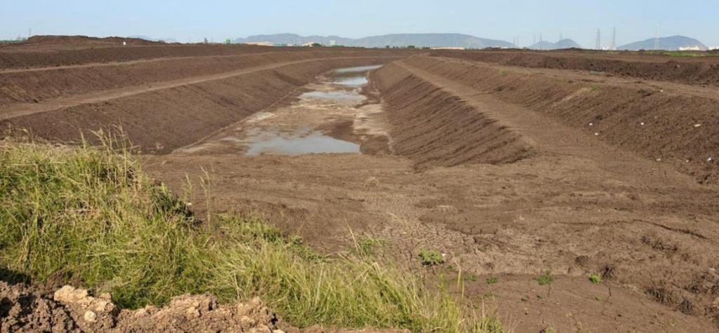
The Andhra Pradesh government is developing Amaravati under the Blue City concept through a major network of reservoirs, canals and flood-control systems designed to protect the capital region from flooding while improving urban planning and tourism.
The project includes Kondaveeti Vagu, Pala Vagu, Gravity Canal and three major reservoirs—Neerukonda, Penumaka and Sakhamuru. Additional reservoirs are also planned at Lam, Pedaparimi and Vykuntapuram.
The government is also planning navigable waterways, boating facilities, cycling tracks and eco-friendly recreational zones around these water bodies.
Since Amaravati is located in the Krishna River floodplain, flood management is directly linked to the survival and sustainability of the capital city.
Blue City Concept of Amaravati
- The Blue City concept means planning a city around its natural water systems instead of treating them merely as drainage channels.
In Amaravati, streams, canals and reservoirs are being integrated into urban development for:
- flood control
• stormwater drainage
• water storage
• tourism and boating
• navigable waterways
• urban greenery
• public recreational spaces - This model is based on the idea that water bodies must remain part of city planning rather than being encroached upon.
- Unlike many Indian cities where lakes and natural drains were blocked and later caused severe urban flooding, Amaravati is being designed by preserving and strengthening natural drainage channels.
- This makes the project both an engineering and environmental planning model.
Amaravati and Krishna River
Amaravati:
Krishna River:
|
Kondaveeti Vagu and Canal System
- Kondaveeti Vagu is the most important natural drainage stream of the Amaravati capital region.
- In South India, the word “Vagu” refers to a seasonal stream or minor tributary that mainly carries runoff during monsoon periods.
- Kondaveeti Vagu originates near Perecharla village in Medikonduru Mandal of Guntur district.
- It collects floodwater from surrounding uplands and agricultural lands and flows through: Lam, Pedaparimi, Neerukonda, Penumaka before joining the Krishna River.
- Its developed stretch is about 23.5 km.
- This stream acts as the primary flood carrier channel of the Amaravati region.
- Instead of covering or diverting it, the government is strengthening and canalising it for controlled discharge.
Pala Vagu
Pala Vagu extends for about 16.5 km from Harsichandrapuram to Krishnayapalem and supports floodwater movement toward Penumaka.
Gravity Canal
- The Gravity Canal is about 7.8 km long and extends from Pitchukulapalem to Vykuntapuram.
- It directly discharges water into the Krishna River using natural gravitational flow, reducing pumping dependency.
- Both Pala Vagu and Kondaveeti Vagu converge at Penumaka Reservoir, from where floodwaters are safely discharged.
Reservoir Network in Amaravati
Major Reservoirs
Reservoir | Capacity | Importance |
Neerukonda Reservoir | 0.4 TMC ft | Largest reservoir and major flood buffer |
Penumaka Reservoir | 0.1 TMC ft | Junction point where canals converge |
Sakhamuru Reservoir | 0.03 TMC ft | Local flood balancing and storage |
- Neerukonda Reservoir is the largest and most important storage point.
- Penumaka Reservoir becomes critical because both Kondaveeti Vagu and Pala Vagu discharge into it before final water release toward the Krishna River.
- Sakhamuru Reservoir helps in localized flood management.
Future reservoirs planned at:
- Lam
• Pedaparimi
• Vykuntapuram
will further strengthen the capital region’s flood resilience.
Significance for Andhra Pradesh
The Blue City project gives Amaravati a long-term urban planning advantage.
It is significant because it:
- protects the capital from flood disasters
• preserves natural drainage systems
• improves groundwater recharge
• supports eco-tourism and water transport
• creates climate-resilient infrastructure
• strengthens Amaravati’s identity as a planned capital - Many Indian cities suffer repeated flooding because urbanization ignored river systems and natural drains.
- Amaravati is attempting to avoid that mistake by planning development according to geography rather than against it.
- This gives the project high importance for APPSC from geography, disaster management and state development perspectives.
CARE MCQ
Q. With reference to the Blue City Project of Amaravati, consider the following statements:
- Kondaveeti Vagu is a seasonal drainage stream that ultimately joins the Krishna River.
- Tungabhadra is a left-bank tributary of the Krishna River.
- Gravity Canal discharges floodwater directly into the Krishna River through natural gravitational flow.
Which of the statements given above are correct?
A. 1 and 3 only
B. 2 and 3 only
C. 1 and 2 only
D. 1, 2 and 3
Ans: (a)
Explanation
Statement 1 is correct : Kondaveeti Vagu is the main natural flood carrier stream of Amaravati and drains into the Krishna River.
Statement 2 is incorrect : Tungabhadra is a right-bank tributary of the Krishna River, not a left-bank tributary.
Statement 3 is correct : the Gravity Canal releases floodwater directly into the Krishna River using natural gravitational flow.
Hence, the correct answer is A.
Q. Consider the following statements regarding the Krishna River system:
- The Krishna River rises near Mahabaleshwar and flows eastward into the Bay of Bengal.
- The Bhima and Tungabhadra are major right-bank tributaries of the Krishna River.
- The Nagarjuna Sagar Project is built across the Krishna River.
Which of the statements given above are correct?
(a) 1 and 2 only
(b) 1 and 3 only
(c) 2 and 3 only
(d) 1, 2 and 3
Ans: (d)
Explanation:
Statement 1 is correct:
The Krishna River originates near Mahabaleshwar in Maharashtra in the Western Ghats. From there, it flows eastward across the Deccan Plateau and finally drains into the Bay of Bengal. It is one of the major peninsular rivers of India and the second-largest east-flowing river of the peninsula after the Godavari.
Statement 2 is correct:
The Bhima and Tungabhadra are important right-bank tributaries of the Krishna River. Since the river flows generally eastward, tributaries joining from the south are treated as right-bank tributaries. Tungabhadra itself is formed by the confluence of the Tunga and Bhadra rivers in Karnataka and is one of the most significant tributaries of Krishna
Statement 3 is correct:
The Nagarjuna Sagar Project, one of the largest masonry dams in India, is constructed across the Krishna River on the border of Telangana and Andhra Pradesh. It is a major multipurpose river valley project providing irrigation, hydroelectric power, and drinking water. It is an important project for southern India.
Q. Consider the following statements regarding the Godavari River in Andhra Pradesh:
- Before entering the Bay of Bengal, the Godavari divides into distributaries forming an extensive delta in coastal Andhra Pradesh.
- The Dowleswaram Barrage is constructed across the Godavari River and is associated with Sir Arthur Cotton.
- The Polavaram Project is a major multipurpose project built on the Pennar River.
Which of the statements given above are correct?
(a) 1 and 2 only
(b) 2 and 3 only
(c) 1 and 3 only
(d) 1, 2 and 3
Ans: (a)
Explanation:
Statement 1 is correct:
The Godavari River, after flowing through Maharashtra, Telangana, and Andhra Pradesh, enters the coastal plains and divides into several distributaries before meeting the Bay of Bengal. This forms the fertile Godavari Delta, which is one of the most agriculturally productive regions of Andhra Pradesh and supports intensive paddy cultivation.
Statement 2 is correct:
The Dowleswaram Barrage is built across the Godavari River near Rajamahendravaram (Rajahmundry). It was originally constructed under the supervision of Sir Arthur Cotton, who played a major role in irrigation development in the Madras Presidency. The barrage transformed agriculture in coastal Andhra by improving irrigation and flood control.
Statement 3 is incorrect:
The Polavaram Project is not built on the Pennar River. It is a major multipurpose irrigation project on the Godavari River in Andhra Pradesh. It is designed for irrigation, hydropower generation, drinking water supply, and inter-basin water transfer. Therefore, the statement is incorrect.
Q. Consider the following statements regarding canals in Andhra Pradesh:
- The Buckingham Canal runs parallel to the Coromandel Coast and passes through parts of Andhra Pradesh.
- It was historically important for inland water transport and irrigation support in the coastal region.
- The canal directly connects the Krishna River basin with the Narmada River basin.
Which of the statements given above are correct?
(a) 1 and 2 only
(b) 2 and 3 only
(c) 1 and 3 only
(d) 1, 2 and 3
Ans: (a)
Explanation:
Statement 1 is correct:
The Buckingham Canal is an important historic canal running parallel to the Coromandel Coast along the eastern coast of India. It passes through parts of Andhra Pradesh and Tamil Nadu and forms part of the inland water transport system along the Bay of Bengal coast
Statement 2 is correct:
The canal was historically significant for navigation, inland water transport, irrigation support, and movement of goods such as rice, salt, and textiles. Before the expansion of railway and road transport, it served as an important economic lifeline for coastal settlements
Statement 3 is incorrect:
The Buckingham Canal does not connect the Krishna basin with the Narmada basin. The Narmada is a west-flowing river in central India with no such canal linkage. Buckingham Canal mainly serves the eastern coastal belt and is associated with coastal navigation rather than inter-basin river transfer of that kind. Therefore, this statement is incorrect.
APPSC Mains Question
Q. Explain how the Blue City concept of Amaravati combines river geography, flood management and sustainable capital city planning.
(250 words)
FAQs
Q1. Why is Krishna River important for Amaravati?
Because Amaravati is located on its floodplain and the river directly influences flood management and urban planning.
Q2. What is Kondaveeti Vagu?
It is the main natural seasonal drainage stream of the Amaravati capital region.
Q3. Which is the largest reservoir in the project?
Neerukonda Reservoir with 0.4 TMC ft capacity.
Q4. Why are canals being made navigable?
To combine flood control with tourism, boating and water-based urban mobility.
Q5. Why is the project called Blue City?