

Why in News?
The Prime Minister is scheduled to inaugurate Alluri Sitarama Raju International Airport at Bhogapuram in Vizianagaram district and launch multiple development projects worth over ₹17,900 crore in Andhra Pradesh on August 1, 2026.

Bhogapuram Airport
- The Alluri Sitarama Raju International Airport at Bhogapuram has been developed as a greenfield airport under the Public-Private Partnership model.
- It has been built at a cost of over ₹5,640 crore and is designed to handle around 6 million passengers annually.
Key Features
- Modern passenger terminal
- AI-enabled airport operations
- Biometric passenger processing
- Automated baggage handling
- Airport Predictive Operations Centre
- Airside 4.0 technologies
- Building Information Modelling
Sustainability Features
- 5 MW solar power plant
- Rainwater harvesting
- Energy-efficient lighting
- Energy-efficient HVAC systems
- Waste management facilities
- EV charging infrastructure
- Environmental monitoring systems
The airport terminal has been designed according to Green Building Standards and reflects Andhra Pradesh’s cultural architecture, including inspiration from Chuttilu cottages and the landscapes of Araku Valley.
ASIP Semiconductor Project at Visakhapatnam
- The foundation stone will be laid for the ASIP Semiconductor Project at Visakhapatnam.
- It is being developed with an investment of over ₹460 crore by ASIP Technologies Pvt. Ltd. in partnership with APACT, Republic of Korea.
Importance
- Andhra Pradesh’s first semiconductor manufacturing facility approved under the India Semiconductor Mission
- Expected to manufacture around 96 million semiconductor chips annually
- Will create high-skilled employment
- Can support ancillary industries in electronics and chip manufacturing
This project strengthens Andhra Pradesh’s entry into high-value technology manufacturing.
Renewable Energy Transmission Projects
The projects include transmission systems linked to renewable energy zones in Kurnool and Ananthapuram.
Major Projects
- Transmission system for Kurnool-IV Renewable Energy Zone Phase-I
- Transmission system for Kurnool Wind Energy Zone and Solar Energy Zone
- Transmission scheme for Solar Energy Zones in Ananthapuram and Kurnool
These projects will help evacuate clean power from renewable energy zones and transmit it through the National Grid.
Importance
- Supports large-scale renewable energy integration
- Improves clean power availability
- Reduces dependence on fossil fuels
- Strengthens India’s energy transition
- Enhances Andhra Pradesh’s role in renewable energy development
National Highway Projects
National Highway projects worth over ₹1,880 crore will also be inaugurated or launched.
Key Projects
- Four-lane greenfield highway from Recherla to Guruvaygudem on NH-365BG
- Four-lane greenfield highway from Guruvaygudem to Devarapalle on NH-365BG
- Four-lane Tadipatri Bypass on NH-67
- High-level bridge at Lingasamudram on NH-565
These projects will improve road safety, reduce travel time, ease congestion and strengthen connectivity between Visakhapatnam and Hyderabad.
Significance for Andhra Pradesh
1. Boost to North Coastal Andhra
Bhogapuram Airport can transform Vizianagaram, Visakhapatnam and Srikakulam into a stronger aviation and investment region.
2. Tourism and Trade Growth
Better air connectivity can support tourism destinations such as Araku Valley, coastal tourism and business travel.
3. Semiconductor Ecosystem
The ASIP project can help Andhra Pradesh attract electronics manufacturing, chip packaging and allied industries.
4. Clean Energy Leadership
Kurnool and Ananthapuram renewable energy transmission projects can strengthen Andhra Pradesh’s position in India’s green energy map.
5. Better Logistics and Mobility
Highway projects can reduce travel time, improve freight movement and support industrial corridors.
6. Employment Generation
Airport operations, semiconductor manufacturing, renewable energy projects and highways can generate direct and indirect employment.
Conclusion
The launch of Bhogapuram Airport and associated projects marks a major infrastructure push for Andhra Pradesh. By combining aviation, semiconductors, renewable energy and highways, the State can strengthen regional connectivity, attract investment and create new employment opportunities. The long-term success of these projects will depend on timely execution, local skills, sustainable operations and industrial ecosystem development.
Why in News?
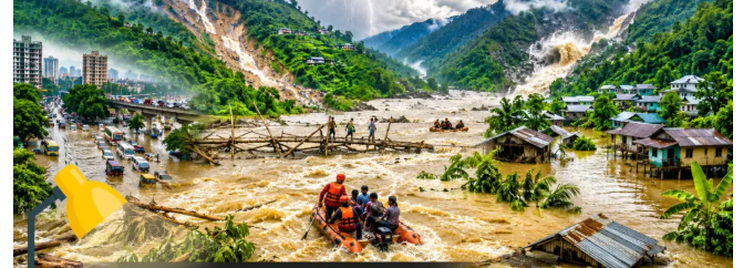
Recent floods in Assam have once again highlighted India’s growing vulnerability to flash floods and extreme rainfall events. The Assam government initially linked the flooding to a possible cloudburst in neighbouring Nagaland. However, weather officials later clarified that the region received heavy rainfall, not rainfall meeting the technical threshold of a cloudburst.This raises an important disaster management issue: not every sudden flood is a cloudburst. Many disasters are caused by a combination of intense rainfall, fragile terrain, poor drainage, weak planning and climate change.
What are Flash Floods?
- A flash flood is a sudden flood that develops within a very short period after rainfall or release of water. Unlike ordinary floods, which may build up over several days, flash floods occur rapidly and leave very little response time.
- According to the broad meteorological understanding, flash floods can occur when flooding develops in less than six hours after intense rainfall. They can also be triggered by other factors such as sudden dam water release or glacial lake overflow.
Difference between Floods and Flash Floods
| Basis | Floods | Flash Floods |
| Time taken | Develop gradually | Develop within a few hours |
| Main cause | Continuous rainfall, river overflow | Intense rain, steep slopes, sudden water release |
| Warning time | Relatively more | Very limited |
| Impact zone | Often wider plains | Hills, river valleys, urban pockets |
| Damage pattern | Waterlogging and inundation | Sudden flow, debris, erosion and destruction |

Cloudburst and Flash Floods
- In India, flash floods are often associated with cloudbursts, but the two are not the same.
- The India Meteorological Department defines a cloudburst as rainfall of more than 100 mm in one hour over a small area of about 20–30 sq. km.
A cloudburst can cause flash floods, but every flash flood is not caused by a cloudburst. Flash floods may also result from:
- prolonged rainfall over saturated soil
- overflowing rivers
- glacial lake outburst
- poor urban drainage
- dam-related water release
- deforestation and slope instability
This distinction is important because wrongly labelling every flood as a cloudburst can hide administrative and planning failures.
Why Flash Floods are Increasing
Flash floods are becoming more frequent due to a mix of climatic and local factors.
1. Climate Change
A warmer atmosphere can hold more moisture. For every 1°C rise in temperature, the atmosphere can hold about 7% more moisture, increasing the possibility of intense rainfall.
2. Concentrated Monsoon Rainfall
Nearly three-fourths of India’s rainfall occurs during the short monsoon period from June to September. This creates heavy river discharge and flood risk.
3. Expanding Vulnerable Zones
Flash flood events have increased notably since the mid-1990s, with many occurring in the Brahmaputra basin, followed by the Ganga and Krishna basins.
4. Changing Land Use
Urbanisation, road construction, deforestation and encroachment of natural drainage channels reduce the land’s ability to absorb rainwater.
| National Disaster Management Authority (NDMA)
What is NDMA?
Vision
Evolution of NDMA
Major Functions of NDMA
Institutional Framework National Level
State Level
District Level
|
Major Drivers in India
A recent scientific study highlighted that flash floods are not caused by rainfall alone. They are often the result of rainfall interacting with local geography and soil conditions.
1. Rainfall and Soil Moisture Combination
Only a portion of flash floods are directly caused by extreme rainfall alone. In many cases, previous rainfall saturates the soil, and later rain quickly turns into surface runoff.
2. Himalayan Geomorphology
In the Himalayas, steep slopes, narrow valleys and high relief accelerate runoff. This makes Himalayan States highly vulnerable to sudden floods.
3. West Coast and Central India Flashiness
Some river sub-basins in the west coast and Central India respond very quickly to rainfall. Their water levels rise sharply after rain, causing sudden flooding.
4. Glacial Lake Risk
In Himalayan regions, melting glaciers are increasing the number and size of glacial lakes. Sudden overflow or breach of such lakes can trigger destructive floods.
5. Urban Surfaces
Concrete roads, buildings and paved surfaces prevent water infiltration. Cities like Mumbai and Chennai have witnessed flash floods due to poor drainage and intense rainfall.
Assam Floods and the Cloudburst
The Assam floods show why technical clarity is necessary in disaster reporting. The flooding was initially attributed to a cloudburst in Nagaland, but meteorological data suggested heavy rainfall over several hours rather than a cloudburst-level event.
This matters because calling an event a cloudburst may make it appear like an unavoidable natural disaster. But in reality, damage may be worsened by:
- weak drainage
- settlement in flood-prone areas
- riverbank erosion
- poor preparedness
- inadequate early warning
- fragile infrastructure
Therefore, disaster analysis must focus not only on rainfall, but also on exposure, vulnerability and preparedness.
Challenges in Preparedness
1. Sparse Monitoring Network
Many vulnerable hill and river-basin areas do not have enough rain gauges or automatic weather stations.
2. Short Warning Time
Flash floods develop quickly, giving authorities and communities very little time to respond.
3. Poor Land-Use Planning
Construction on floodplains, riverbeds and unstable slopes increases disaster losses.
4. Weak Drainage Infrastructure
Urban and rural drainage systems are often unable to handle intense short-duration rainfall.
5. Climate Uncertainty
Climate change is making rainfall more intense and less predictable, increasing the difficulty of risk planning.
Way Forward
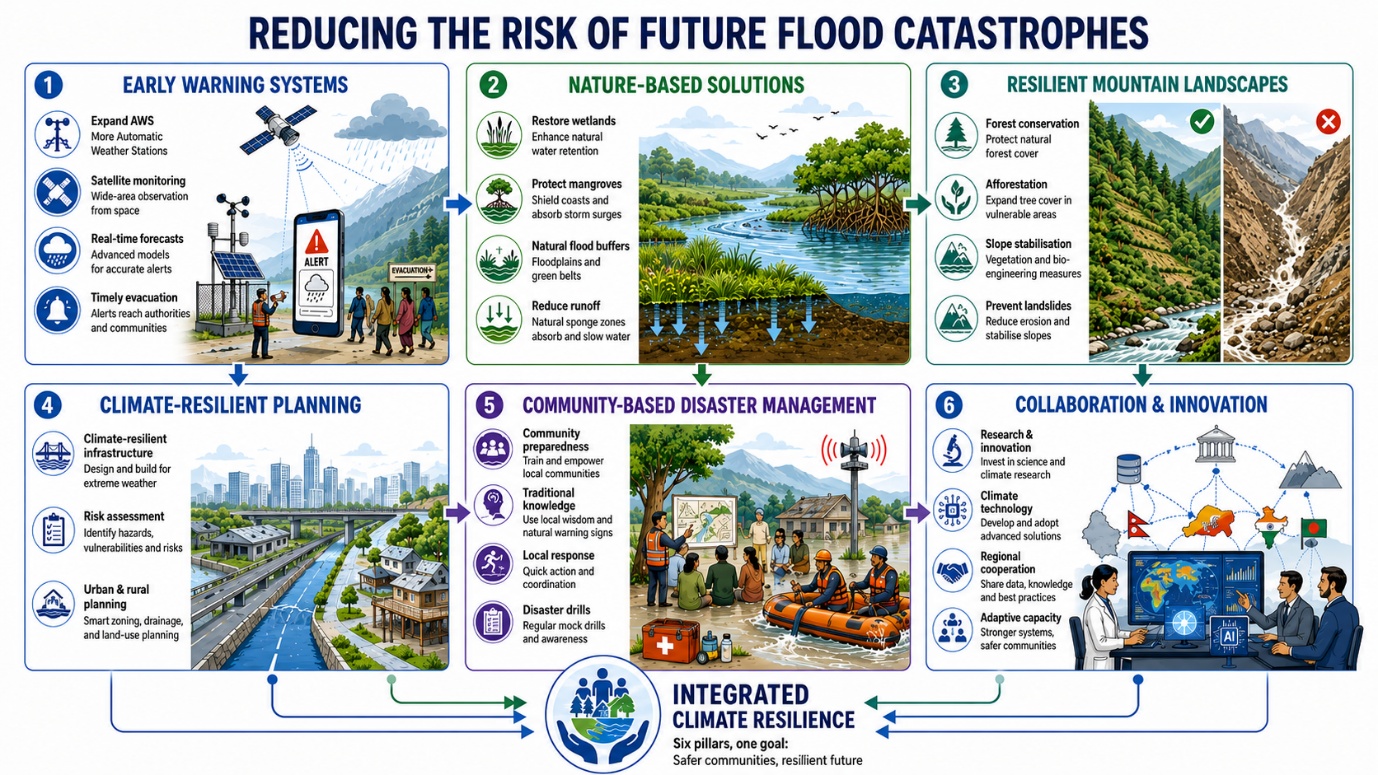
1. Strengthen Early Warning Systems
India needs more Automatic Weather Stations, Doppler radars, satellite-based observation and real-time rainfall monitoring in vulnerable regions.
2. Promote Nature-Based Solutions
Wetlands, forests, mangroves and natural drainage channels should be restored because they absorb floodwaters and reduce runoff.
3. Adopt Risk-Informed Land Use
Floodplains, riverbeds and landslide-prone slopes must be kept free from unsafe construction.
4. Build Climate-Resilient Infrastructure
Roads, bridges, drains and embankments must be designed for extreme rainfall and future climate risks.
5. Use Region-Specific Planning
Himalayan, coastal, urban and central Indian regions require different flood management strategies based on local topography and soil conditions.
6. Involve Communities
Local communities should be trained in warning response, evacuation and disaster preparedness. Traditional knowledge can also improve early warning.
7. Update Hazard Mapping
Fresh flood-risk maps should guide infrastructure planning, settlement expansion and disaster response.
Conclusion
Flash floods are sudden, destructive and increasingly linked with climate change. However, their impact is not determined by rainfall alone. Poor land-use planning, weak drainage, deforestation and inadequate warning systems convert extreme weather into disasters. India must shift from a relief-centric approach to risk-informed, climate-resilient and community-based disaster management.
Why in News?
Mega data centre projects in Andhra Pradesh and Maharashtra are facing strong public resistance. In Visakhapatnam and Anakapalli, a Google-linked company is developing a 1 GW AI data centre hub, while in Thane, Amazon is developing a large hyperscale data centre project.Citizens’ groups are not opposing technology or investment itself. Their concerns are mainly about water use, power demand, environmental impact, lack of transparency and limited local benefits.

What are Data Centres?
A data centre is a specialised facility used to store, process and manage large volumes of digital data.
It contains:
- servers
- storage systems
- networking equipment
- cooling systems
- power supply units
- backup systems
- cybersecurity and physical security infrastructure
Data centres support modern digital services such as cloud computing, artificial intelligence, digital payments, e-governance, e-commerce, online banking and social media.
India’s Digital Infrastructure Evolution
Timeline: 2018–2026
| Year | Development | Importance |
| 2018 | RBI mandated local storage of financial data | Increased domestic data storage demand |
| 2020 | Draft National Data Centre Policy released | Proposed incentives and dedicated data centre zones |
| 2022 | Data centres classified as infrastructure | Improved access to institutional finance |
| 2023 | Digital Personal Data Protection Act established | Strengthened data processing and domestic storage framework |
| 2024 | IndiaAI Mission launched | Expanded GPU and high-computing capacity |
| 2025 | Policy push for private nuclear participation | Linked to long-term energy needs of data centres |
| 2026 | Tax incentives for foreign firms using India-based data centres | Encouraged global cloud services in India |
Why Data Centres are Growing in India
India’s data centre demand is rising due to the rapid expansion of the digital economy.
1. Digitalisation and Data Generation
India’s use of e-governance, UPI, e-commerce, smartphones, 5G and online services is generating huge volumes of data that require domestic storage and processing.
2. Artificial Intelligence and Cloud Computing
AI models and cloud services need high-performance computing infrastructure. This is pushing companies to build large AI-ready data centres.
3. Data Localisation and Digital Sovereignty
The need to store and process Indian users’ data within India is encouraging domestic data centre capacity.
4. Government Incentives
Several States are offering land, power, tax benefits, stamp-duty exemptions and faster clearances to attract data centre investment.
5. Global Private Investment
Large technology companies such as Google, Amazon, Microsoft and others are expanding data infrastructure in India.
Recent Protests in Visakhapatnam and Thane
Visakhapatnam-Anakapalli Project
- The Andhra Pradesh government allotted about 601 acres across three locations: Adavivaram-Mudasarlova, Tarluvada and Rambilli. The project is being developed as a 1 GW AI data centre hub.
- Local groups have raised concerns about pressure on water, power and ecologically sensitive areas, including areas around Kambalakonda Eco-Forest, Rambilli Wildlife Sanctuary and Mudasarlova reservoir.
Thane Project
- In Maharashtra, residents are opposing Amazon’s proposed hyperscale data centre in Balkum Pada and Majiwada. The project is spread across 53.73 acres and requires large power support.
- Residents have demanded clarity on water usage, noise levels, air quality impact, public hearing and benefits for local communities.
Major Concerns
1. Water Stress
Data centres need cooling systems, and some cooling technologies require large amounts of water. In water-stressed cities, this creates conflict between industrial use and public drinking water needs.
In Thane, residents have pointed to confusion over the actual water requirement, with different figures being cited by the company and local authorities.
2. Pressure on Power Grid
Mega data centres require continuous electricity. The Thane project reportedly needs 422 MW of power and large backup capacity. AI data centres can create high and sudden electricity demand, increasing pressure on transmission networks.
3. Environmental Impact
Large construction, diesel generators, cooling infrastructure and high energy consumption can increase emissions, noise pollution and ecological stress, especially when projects are near forests, reservoirs or residential zones.
4. Limited Permanent Employment
Data centres create jobs during construction, but after completion they are highly automated and capital-intensive. This raises the question of whether local communities receive benefits proportionate to the resources used.
5. Weak Public Consultation
Citizens’ groups argue that project details, environmental data and resource-use estimates are not always clearly placed in the public domain. This creates mistrust.
6. Unplanned Urban Development
Locating large data centres in already crowded or water-stressed residential areas can worsen existing problems such as water shortage, load shedding and traffic pressure.
Way Forward
1. Transparent Resource Disclosure
Before approval, companies should publicly disclose verified estimates of water use, power demand, emissions, cooling method, waste generation and backup systems.
2. Mandatory Public Consultation
Local communities, municipal bodies and environmental groups should be consulted through proper public hearings.
3. Water-Sensitive Cooling
Projects should use treated wastewater, closed-loop cooling, rainwater harvesting and water-efficient technologies, not drinking-water sources.
4. Renewable Energy Use
Data centres should shift towards renewable power, energy-efficient servers and battery-based backup, reducing dependence on fossil fuels and diesel generators.
5. Proper Site Selection
Large data centres should not be located near ecologically sensitive zones, reservoirs, water-stressed neighbourhoods or dense residential areas.
6. Local Benefit-Sharing
Project approvals should include commitments on local jobs, skill development, infrastructure improvement and opportunities for local businesses.
7. Independent Monitoring
There should be real-time monitoring of water and power use, noise levels, air quality and environmental compliance, with public reporting.
Conclusion
Data centres are essential for India’s digital economy, AI ambitions and data sovereignty. But they are not invisible technology projects; they are large physical infrastructure projects that consume land, water and electricity. The protests in Visakhapatnam and Thane show that India must treat data centres as sustainable infrastructure, not merely as investment projects. The future of digital India must be built on transparency, ecological responsibility and community consent.