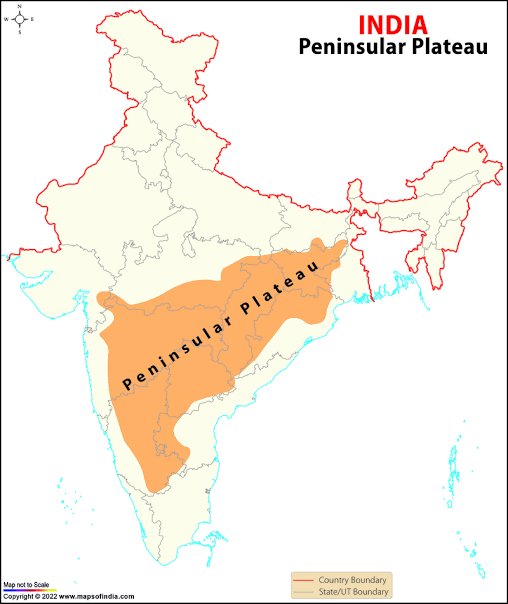
The Peninsular Plateau is a large, irregular triangular region in India that rises from an elevation of about 150 meters above the river plains to between 600 and 900 meters.This plateau is among the oldest and most stable landmasses in India, distinguished by a range of unique physical features and varied geological formations.It is surrounded by significant mountain ranges and extends into various smaller plateaus and highlands.
General Characteristics
- Elevation: Ranges from 150 meters to 900 meters.
- Boundaries:
- Northwest: Delhi Ridge, an extension of the Aravallis.
- East: Rajmahal Hills.
- West: Gir Range.
- South: Cardamom Hills.
- Northeast: Shillong and Karbi-Anglong Plateaus.
- Features:
- Physiographic Features: Includes tors, block mountains, rift valleys, spurs, bare rocky structures, hummocky hills, and quartzite dykes.
- Soil: Predominantly black soil in the western and northwestern parts.
- Geological Activity: Experienced recurrent upliftment and submergence, crustal faulting, and fractures (e.g., Bhima Fault).
Major Regions of the Peninsular Plateau
The Peninsular Plateau can be broadly divided into three major regions:
The Deccan Plateau
- Boundaries:
- West: Western Ghats.
 East: Eastern Ghats.
- North: Satpura, Maikal, and Mahadeo Hills.
- Western Ghats:
- Names: Sahyadri (Maharashtra), Nilgiri Hills (Karnataka and Tamil Nadu), Anaimalai Hills and Cardamom Hills (Kerala).
- Elevation: Average about 1,500 meters; highest peak is Anaimudi (2,695 meters), followed by Dodabetta (2,637 meters).
- Significance: Origin of most Peninsular rivers.
- Eastern Ghats:
- Characteristics:Comprised of scattered low hills, extensively eroded by rivers like the Mahanadi, Godavari, Krishna, and Kaveri.
- Ranges: Includes Javadi Hills, Palconda Range, Nallamala Hills, and Mahendragiri Hills.
- Intersections: The Western and Eastern Ghats converge at the Nilgiri Hills.
The Central Highlands
- Boundaries:
- West: Aravalli Range.
- South: Satpura Range (elevation between 600-900 meters).
- East: Extends to Jaisalmer, covered by longitudinal sand ridges and crescent-shaped sand dunes.
- Features:
- Relict Mountains: Highly denuded and discontinuous ranges.
- Geological History: Presence of metamorphic rocks such as marble, slate, and gneiss.
- Elevation: Ranges between 700-1,000 meters; slopes towards the north and northeast.
- Rivers:
- Yamuna: Originates in the Vindhyan and Kaimur ranges.
- Chambal: Banas is a significant tributary originating from the Aravallis.
- Rajmahal Hills:
- Location: Eastern extension of the Central Highlands.
- Resource: Rich in mineral resources.
The Northeastern Plateau
- Characteristics:
- Extension: Detached from the main Peninsular Block due to a fault created by the northeastward movement of the Indian plate during the Himalayan origin.
- Depression: Filled by deposition activity of numerous rivers.
- Regions:
- Meghalaya Plateau:
- Subdivisions:
- Garo Hills
- Khasi Hills
- Jaintia Hills
- Resources: Rich in coal, iron ore, sillimanite, limestone, and uranium.
- Climate: Receives maximum rainfall from the southwest monsoon, resulting in highly eroded surfaces.
- Features: Cherrapunji exhibits a bare rocky surface with minimal vegetation.
- Subdivisions:
- Meghalaya Plateau:
- Karbi-Anglong Plateau:
- Location: Assam.
- Characteristics: Similar to the Meghalaya Plateau in terms of geological and climatic conditions.