Ocean Relief Features
Water Distribution on Earth:
- About 71% of Earth’s water is found in the oceans.
- The remaining water is freshwater distributed as glaciers, icecaps, groundwater, lakes, soil moisture, atmosphere, streams, and within living organisms
- Approximately 59% of water that falls on land returns to the atmosphere through evaporation over oceans and other areas, while the rest runs off, infiltrates into the ground, or contributes to glaciers.
| Source | Percentage |
| Oceans | 97 |
| Ice Caps and Glaciers | 2 |
| Groundwater | 0.68 |
| Lakes | 0.1 |
| Soil | 0.005 |
| Atmosphere | 0.001 |
| Streams and Rivers | 0.0001 |
Ocean Floor
- The ocean floors are rugged, containing the world’s largest mountain ranges, deepest trenches, and vast plains, with most of the ocean floor lying 3-6 km below sea level.
- Ocean basins result from tectonic activity and were formed from volcanic rock released at mid-ocean ridges.
- They are geologically younger than the oldest continental rocks.
- Therefore, oceanic relief is primarily shaped by tectonic, volcanic, erosional, and depositional processes and their interactions.
Introduction
- Ocean relief refers to the variations in elevation and depression on the ocean floor.
- These features result from tectonic, volcanic, erosional, and depositional processes over geological time.
- Ocean relief features are broadly classified into:
- Major Relief Features
- Minor Relief Features
Major Ocean Relief Features
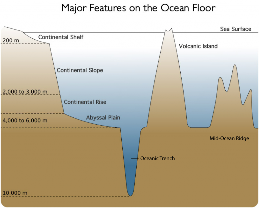
1. Continental Shelf
- The continental shelf is the gently sloping seaward extension of the continental plate, covered by shallow seas and gulfs, with a gradient of 1° or less.
- It comprises 7.5% of the total ocean area and usually concludes with a steep incline known as the shelf break.
- Sediments from rivers and glaciers are deposited here. The average width of shelves is 70-80 km, with depths ranging from 30 m to 600 m.
- Shelves are narrow or absent along margins like Chile and Sumatra, while the eastern USA shelf is about 120 km wide. The Siberian shelf, at 1,500 km, is the world’s largest.
Examples:
- SE Asia’s extensive shelf.
- Grand Banks near Newfoundland.
- Submerged land between Australia and New Guinea.
Types of Continental Shelves:
- Glaciated shelf: Greenland
- Coral reef shelf: Queensland, Australia
- Riverine shelf: Nile Delta
- Dendritic shelf: Hudson River mouth
Width:
- Ranges from 70–1500 km.
- Siberian Shelf (Arctic Ocean) is the widest at ~1500 km.
Depth: Between 30–600 meters.
Importance:
- Rich in marine life (best fishing zones).
- Major source of petroleum and gas (20% of world production).
- Source of polymetallic nodules and other minerals.
2. Continental Slope
- Steep slope connecting the continental shelf to deep ocean basins.
- Marks the true edge of the continents.
- Gradient: 2° to 5°.
- Depth: 200 to 3000 meters.
- Canyons and trenches may be present here.
3. Continental Rise
- Found at the base of the continental slope.
- Gradient: 0.5° to 1°.
- Formed by sediment accumulation.
- Smoothly merges with the abyssal plain.
4. Abyssal Plain (Deep Sea Plain)
- Flat, featureless, and extensive deep-ocean floors.
- Covers nearly 40% of the ocean floor.
- Depth: 3000 to 6000 meters.
- Made up of fine sediments like clay and silt.
- Among the flattest regions on Earth due to sediment deposition.
Minor Ocean Relief Features
1. Oceanic Trenches (Deeps)
- Narrow, steep-sided depressions.
- Deepest parts of ocean basins (e.g. Mariana Trench: >11,000 m).
- Formed by subduction zones (ocean-ocean or ocean-continent convergence).
- Associated with strong earthquakes and volcanic arcs.
- Mostly found in the Pacific Ocean.
2. Mid-Oceanic Ridges
- Underwater mountain chains formed by divergent plate boundaries.
- Total length: ~75,000 km (Earth’s largest mountain system).
- Characterized by a central rift valley.
- Examples: Mid-Atlantic Ridge, visible in Iceland.
3. Seamounts
- Submerged volcanic mountains with conical peaks.
- Do not reach the ocean surface.
- Volcanic in origin.
- Example: Emperor Seamount Chain (Pacific Ocean).
4. Guyots
- Flat-topped seamounts eroded by wave action.
- Common in the Pacific Ocean.
- Indicative of past volcanic activity followed by subsidence.
5. Submarine Canyons
- Deep, narrow valleys or gorges cut into the continental slope/shelf.
- Formed by turbidity currents or river erosion.
- Types:
- Canyon beginning at shelf edge (e.g. Oceanographer Canyon)
- Canyon at river mouths (e.g. Zaire, Mississippi)
- Dendritic canyons (e.g. off California coast)
- Hudson Canyon is the most studied.
6. Atolls
- Ring-shaped coral islands enclosing a lagoon.
- Formed from submerged volcanic islands with coral growth around them.
- Common in tropical oceans.
7. Banks, Shoals, and Reefs
- Bank: Elevated seafloor area with navigable depth (e.g. Grand Bank).
- Shoal: Shallow submerged ridge, dangerous for ships.
- Reef: Rock or coral ridges near the ocean surface.
- Coral reefs are found mostly in the Pacific and Indian Oceans.
- Example: Great Barrier Reef, Australia.
Significance of Ocean Relief Study
- Influences marine navigation, fisheries, and undersea cable laying.
- Controls ocean currents, affecting global climate.
- Helps in understanding plate tectonics and past geological history.
- Crucial for locating mineral and energy resources.
- Affects biodiversity and ecosystems in oceans.