
- IRNSS is an independent regional navigation satellite system being developed by India.
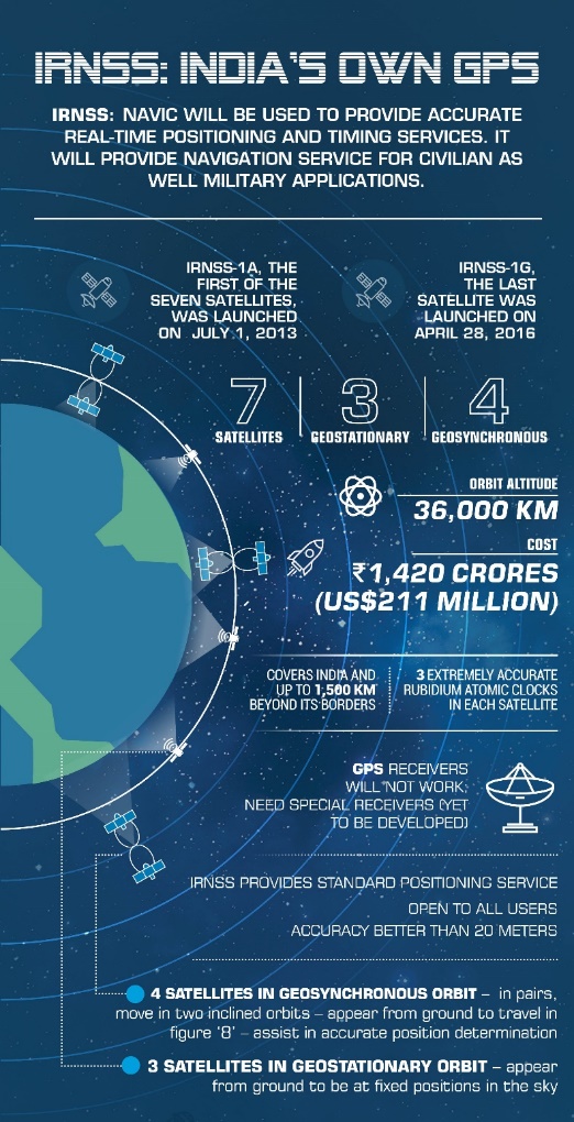
- It is designed to provide accurate position information service to users in India as well as the region extending up to 1500 km from its boundary, which is its primary service area.
- An Extended Service Area lies between primary service area and area enclosed by the rectangle from Latitude 30 deg South to 50 deg North, Longitude 30 deg East to 130 deg East.
- IRNSS will provide two types of services, namely,
- Standard Positioning Service (SPS) which is provided to all the users and
- Restricted Service (RS), which is an encrypted service provided only to the authorised users.
- The IRNSS System is expected to provide a position accuracy of better than 20 m in the primary service area.
- To meet the positioning, navigation and timing requirements of the nation, ISRO has established a regional navigation satellite system called Navigation with Indian Constellation (NavIC).
- NavIC was erstwhile known as Indian Regional Navigation Satellite System (IRNSS).
- NavIC is designed with a constellation of 7 satellites and a network of ground stations operating 24 x 7.
- Three satellites of the constellation are placed in geostationary orbit, at 32.5°E, 83°E and 129.5°E respectively, and four satellites are placed in inclined geosynchronous orbit with equatorial crossing of 55°E and 111.75°E respectively, with inclination of 29° (two satellites in each plane).
- The ground network consists of control centre, precise timing facility, range and integrity monitoring stations, two-way ranging stations, etc.
- NavIC offers two services: Standard Position Service (SPS) for civilian users and Restricted Service (RS) for strategic users.
- IRNSS-1A, 1B, 1C, 1D, 1E, 1F and 1G were launched by PSLV-C22, PSLV-C24, PSLV-C26, PSLV-C27, PSLV-C31, PSLV-C32, and PSLV-C33, in July 2013, April 2014, October 2014, March 2015, January 2016, March 2016 and April 2016 respectively.
- Like all other IRNSS satellites, IRNSS-1I also has a lift-off mass of 1425 kg. The configuration of IRNSS-1I is similar to IRNSS-1A, IRNSS-1B, IRNSS-1C, IRNSS-1D, IRNSS-1E, IRNSS-1F, and IRNSS-1G. IRNSS-1I was launched by PSLV-C41
- IRNSS-1H Satellite could not be placed into the orbit as mission was unsuccessful.
Few applications:
- Transportation (terrestrial, aerial and marine)
- Location based services
- Personal mobility
- Resource monitoring
- Surveying and geodesy
- Scientific research
- Time dissemination and synchronisation
- Safety-of-life alert dissemination
Note: Elena Geo Systems, a Bengaluru based Space Technology Company, introduced India’s First NavIC – Based PNT Device. PNT devices stands for Positioning, Navigation and Timing devices. The PNT device can be easily connected to a smartphone using the On-The-Go (OTG) connector.
