Latitude, Longitude, and Time
Introduction
- The Earth is not a perfect sphere but an oblate spheroid due to equatorial bulging.
- To locate places, a network of imaginary lines is drawn, forming the geographical grid.
- The grid consists of parallels of latitude (horizontal lines) and meridians of longitude (vertical lines).
Parallels of Latitude
- Definition: The angular distance of a point north or south of the Equator.
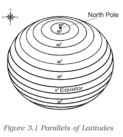 The Equator is 0° latitude, dividing the Earth into Northern and Southern Hemispheres.
- Poles are at 90° N (North Pole) and 90° S (South Pole).
- Latitudes are measured in degrees (°), minutes (‘), and seconds (“).
- Total Parallels: 179 (including Equator).
- Major Latitudes:
- 0° – Equator
- 23.5° N – Tropic of Cancer
- 23.5° S – Tropic of Capricorn
- 66.5° N – Arctic Circle
- 66.5° S – Antarctic Circle
- 90° N – North Pole, 90° S – South Pole
- Distance between latitudes: ~111 km per degree.
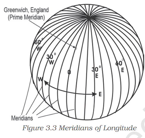 Meridians of Longitude
- Definition: The angular distance east or west of the Prime Meridian (0°).
- Unlike latitude, all longitudes are equal in length.
- Prime Meridian (0°) passes through Greenwich, London.
- Range: 0° to 180° east and west.
- Longitude helps in determining time zones.
- Distance between longitudes varies:
- 111.3 km at the Equator
- 79 km at 45° latitude
- 0 km at the poles (converging points)
Longitude and Time
- The Earth rotates 360° in 24 hours, moving 15° per hour.
- Each degree of longitude accounts for 4 minutes of time difference.
- Eastward movement = Time increases (+4 min per degree).
- Westward movement = Time decreases (-4 min per degree).
Example Calculations:
- If GMT (Greenwich Mean Time) is 12:00 noon:
- Thimpu (90° E) → Local Time = 6:00 PM
- New Orleans (90° W) → Local Time = 6:00 AM
Standard Time and Time Zones
- Each country adopts a Standard Meridian for uniform timekeeping.
- Indian Standard Time (IST):
- 82°30′ E (Mirzapur, Uttar Pradesh).
- IST is GMT +5:30 hours.
- Countries with large east-west spans have multiple time zones (e.g., USA, Russia, Canada).
- Total time zones worldwide: 24.
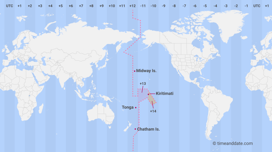
International Date Line (IDL)
- Located at 180° longitude (opposite the Prime Meridian).
- Separates different calendar dates.
- Eastward crossing → +1 day.
- Westward crossing → -1 day.
- Not a straight line; zigzags to accommodate political and national borders.
Key Differences Between Latitude and Longitude
| Feature | Latitude | Longitude |
| Definition | Distance north/south of Equator | Distance east/west of Prime Meridian |
| Reference Line | Equator (0°) | Prime Meridian (0°) |
| Range | 0° to 90° N/S | 0° to 180° E/W |
| Shape | Parallel Circles | Semi-circles, converging at poles |
| Use | Determines climate zones | Determines time zones |
Source: NCERT