Definition and Formation of Clouds
- Clouds are visible masses of minute water droplets or ice crystals suspended in the atmosphere.
- They form when moist air rises, cools adiabatically, and reaches its dew point, causing condensation around hygroscopic nuclei like dust, salt, or smoke particles.
Clouds are a key link between condensation and precipitation in the hydrological cycle.
Role of Clouds in Climate Regulation
Clouds play a dual role in Earth’s energy balance and climate system:
Cooling Effect:
- Reflect a portion of incoming solar radiation (albedo effect).
- Thick, low clouds (e.g., stratus) have high albedo, keeping surfaces cooler.
Warming Effect:
- Trap outgoing longwave radiation emitted from Earth’s surface.
- Thin, high clouds (e.g., cirrus) enhance greenhouse warming.
The net impact depends on cloud type, altitude, and coverage.
Reasons for Cloud Colour and Appearance
- White Clouds: Appear white due to scattering of all visible light wavelengths by the water droplets/ice crystals.
- Grey or Dark Clouds: Appear dark because they are thicker and denser, allowing less sunlight to pass through.
- Brilliant Colours at Sunrise/Sunset: Due to Rayleigh scattering of shorter wavelengths and diffraction through moisture layers.
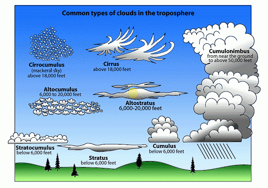
Types of Clouds
Clouds are classified based on:
(A) Shape (form or appearance)
(B) Altitude (height above ground level)
A. Classification Based on Shape
1. Cirrus Clouds
- Appearance: High, thin, wispy, feather-like.
- Altitude: 8,000 – 12,000 m
- Composition: Ice crystals
- Weather: Indicate fair weather, but may signal approaching disturbance.
2. Cumulus Clouds
- Appearance: White, fluffy, cotton-like with flat bases.
- Altitude: 1,000 – 6,000 m
- Weather: Fair weather; if vertical development occurs → may turn into cumulonimbus (thunderclouds).
3. Stratus Clouds
- Appearance: Low, uniform grey layer covering the sky like a blanket.
- Altitude: Up to 2,000 m
- Weather: Dull, overcast days; may bring light drizzle.
B. Classification Based on Altitude
1. Low Clouds (Surface to ~2,000 m)
a) Stratocumulus
- Low, lumpy, grey clouds.
- May bring light rain or drizzle.
b) Stratus
- Flat, uniform grey clouds.
- Associated with gloomy, overcast conditions.
c) Nimbostratus
- Thick, dark grey rain clouds.
- Produce continuous, steady rainfall or snowfall.
2. Middle Clouds (2,000 – 6,000 m)
a) Altostratus
- Grey or blue-grey sheets, covering the entire sky.
- May allow diffused sunlight; bring light rain or snow.
b) Altocumulus
- White or grey patches, often arranged in groups.
- May indicate instability and possible thunderstorms.
3. High Clouds (Above 6,000 m)
a) Cirrus
- Wispy, ice-crystal clouds (already discussed above).
- Appear before weather changes.
b) Cirrostratus
- Thin, veil-like clouds covering the sky.
- May cause halo around the sun or moon.
c) Cirrocumulus
- Small, white flakes or ripples in patches.
- “Mackerel sky” appearance; no precipitation.
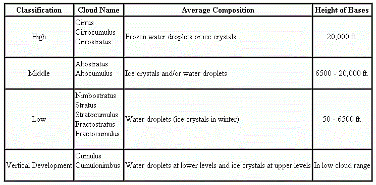
| Category | Cloud Type | Appearance | Weather |
| High Clouds | Cirrus, Cirrostratus, Cirrocumulus | Wispy, thin, patchy | Fair weather, change indication |
| Middle Clouds | Altostratus, Altocumulus | Grey, layered, grouped | Light rain, thunderstorms |
| Low Clouds | Stratus, Stratocumulus, Nimbostratus | Grey blanket/cloud banks | Overcast, drizzle, rain |
| Vertical | Cumulus, Cumulonimbus | Puffy/towering | Fair to severe weather |