Fronts:
The boundary zone between the two air masses meet point is called the front. These air masses are brought together by the converging movement in the general atmospheric circulation. The process by which fronts are forming is known as frontogenesis, and the end-stage of a front is called frontolysis. They come into contact with the sloping boundaries.These boun
daries represent the transition zone with a stark contrast in weather conditions.These masses are vast in size covering tens and thousands of kilometres. The front brings abrupt changes in temperature and causes the air to rise to form clouds and cause precipitation.
we Recognize fronts by the following observations:
- Temperature is changing sharply across shorter distances.
- Moisture content is changing
- Wind direction is shifting rapidly
- Pressure changes
- Patterns of cloud and precipitations
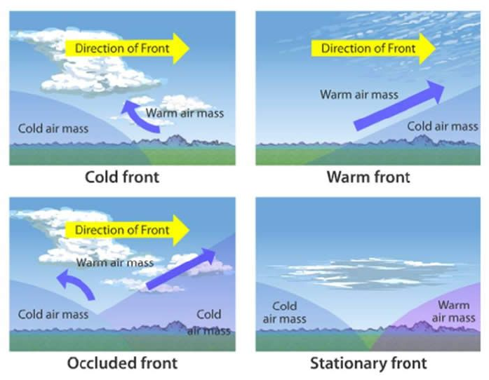
Types of Front
- Stationary Fronts: When air masses are not moving against each other, then the zone is called a stationary zone. In this zone, there is no movement of an actual temperature gradient, but convergence is still there.
- Cold Fronts: The transition zone where cold and dry stable air mass displaces a warm moist unstable subtropical air mass than the zone is called cold fronts. The dense cold air moves into the warm air region, and it forces warm air to rise very quickly. This will result in convective clouds and heavier precipitations.
- Warm Fronts: The transition zone in the atmosphere where moist subtropical moist air displaces retreating cold, dry polar air mass. Gradual frontal lifting will cause the formation of clouds and precipitations. We can see moderate and gentle precipitation over a large area for several hours. The formation of clouds after the warm airlifting is not convective in nature, so we get stratus precipitation.
- Occluded Fronts: These fronts form when the air mass is fully lifted above the land surface by the fast-moving air mass coming from behind. For example, a fast-moving cold front catches and overtakes a slower-moving warm front. The cyclone will decrease the intensity after the occlusion when the warm air is forced upwards between the two cold air masses then the weather becomes clear, calm, and stable.
Movement and Interaction
- Jet Streams: High winds like jet streams guide the movement of fronts across the Earth’s surface over several days.
- Landforms: Features like mountains can alter the path of convergence and movement of fronts.