Table of Contents
Relevance: TGPS Disaster Management, Science and Technology
Prelims
INCOIS, ITEWC, UNESCO-IOC, Tsunami Ready Recognition Programme, Sumatra-Andaman Subduction Zone, GNSS, GIS, tsunami buoy, tide gauge, Bottom Pressure Recorder
Mains
Community resilience, multi-hazard early warning, last-mile connectivity, disaster-risk reduction, coastal vulnerability, evacuation planning, inter-agency coordination, technology-enabled preparedness
Why in News?
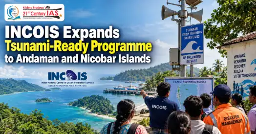
The Indian National Centre for Ocean Information Services (INCOIS) is preparing to expand the UNESCO-IOC Tsunami Ready Recognition Programme to the Andaman and Nicobar Islands.Around 30 villages have been identified in the first phase in coordination with the islands’ Directorate of Disaster Management. The initiative follows the successful recognition of 26 villages in Odisha as tsunami-ready communities.
What is a Tsunami?
A tsunami is a series of powerful sea waves caused by the sudden displacement of a large volume of ocean water. It may be triggered by:
- Undersea earthquakes
- Submarine landslides
- Volcanic eruptions
- Collapse of coastal or oceanic landforms
Unlike ordinary wind-generated waves, tsunami waves can travel across entire ocean basins at high speed. Their height increases sharply when they approach shallow coastal waters, producing severe flooding and destruction.
Why are the Andaman and Nicobar Islands Vulnerable?
The Andaman and Nicobar Islands are located close to the Sumatra-Andaman Subduction Zone, one of the world’s most seismically active regions.
A subduction zone is an area where one tectonic plate moves beneath another. The resulting stress can produce powerful undersea earthquakes capable of generating tsunamis.
The islands face greater risk because:
- They are located close to the potential tsunami source.
- They may be among the first Indian territories to experience tsunami waves.
- The time available for issuing warnings and conducting evacuation may be very short.
- Settlements are scattered across several islands.
- Communication and transport between remote areas can be difficult.
- Many communities, public facilities and livelihood activities are concentrated near the coast.
INCOIS notes that near-source regions such as the Andaman and Nicobar Islands may have only about 10–20 minutes of lead time, making immediate local response essential.
About INCOIS
- The Indian National Centre for Ocean Information Services is an autonomous institution established in 1999 under the Ministry of Earth Sciences. It is headquartered in Hyderabad and operates as part of the Earth System Science Organisation.
INCOIS provides ocean-information and advisory services relating to:
- Tsunamis
- Storm surges
- High waves
- Ocean conditions
- Potential fishing zones
- Coastal and marine hazards
- Its Indian Tsunami Early Warning Centre provides round-the-clock tsunami-monitoring and warning services. INCOIS has also been recognised by the Intergovernmental Oceanographic Commission of UNESCO as a regional tsunami service provider for Indian Ocean countries.
Indian Tsunami Early Warning Centre
- The Indian Tsunami Early Warning Centre (ITEWC) was established at INCOIS following the devastating Indian Ocean Tsunami of December 26, 2004. It became fully operational in October 2007.
- It is the national authority responsible for issuing tsunami advisories in India. It also functions as an approved service provider under the Indian Ocean Tsunami Warning and Mitigation System coordinated by UNESCO’s Intergovernmental Oceanographic Commission.
Components of the Warning System
The warning system integrates:
- Real-time seismic stations
- Tsunami buoys
- Bottom Pressure Recorders
- Tide gauges
- Numerical tsunami models
- Pre-run disaster scenarios
- Vulnerability models
- Decision-support systems
- Satellite and terrestrial communication networks
The system operates continuously and can detect potentially tsunami-generating earthquakes in the Indian Ocean and other regions. Advisories are disseminated through SMS, email, fax, websites and other communication systems.
What is the Tsunami Ready Recognition Programme?
The Tsunami Ready Recognition Programme (TRRP) is an international, community-based initiative of the Intergovernmental Oceanographic Commission of UNESCO.
It does not claim that a community is free from tsunami risk. Instead, it recognises that the community has achieved a standard level of preparedness to:
- Understand its tsunami risk
- Receive official warnings
- Communicate warnings to residents
- Evacuate people quickly
- Conduct regular awareness programmes and drills
Recognition is based on 12 indicators and is renewable every four years.
Technology & Early-Warning Infrastructure
- GNSS Sensors & Sirens: INCOIS has installed ~35 interconnected GNSS sensors with sirens across the Andaman & Nicobar Islands to monitor ground movement and issue warnings.
- Faster Warnings: Efforts are underway to reduce tsunami-warning dissemination time for India’s east coast from ≤10 minutes to below 5 minutes.
- Satellite Communication: Existing satellite networks will ensure warning transmission even when terrestrial communication fails.
- Regional Centre: INCOIS is considering a dedicated island-based centre for monitoring, coordination, training and response.
- Underwater Sensor Cable: A proposed 150-km sensor cable at 2,000–2,500 ft depth will monitor ocean-floor seismic activity and improve tsunami detection.
- GIS & Community Preparedness: Training focuses on hazard/evacuation mapping, vulnerable areas, critical infrastructure, safe zones and evacuation routes.
- Expansion: INCOIS aims to make 75 villages in Odisha and 9 villages in Kerala tsunami-ready.
Conclusion
The expansion of the Tsunami Ready Recognition Programme to the Andaman and Nicobar Islands represents a shift from warning generation to community-level preparedness. Advanced sensors and faster alerts are essential, but they must be supported by evacuation maps, reliable communication, regular drills and public awareness. By integrating science, institutions and community participation, India can build an effective end-to-end tsunami-warning system and minimise the loss of life in its most vulnerable coastal regions.
CARE MCQ
Q. Consider the following statements regarding the Tsunami Ready Recognition Programme:
- It is a community-based initiative of UNESCO’s Intergovernmental Oceanographic Commission.
- Its indicators are grouped under assessment, preparedness and response.
- Recognition means that a community is completely free from tsunami risk.
- INCOIS supports its implementation in India.
Which of the statements given above are correct?
(a) 1 and 2 only
(b) 1, 2 and 4 only
(c) 2, 3 and 4 only
(d) 1, 2, 3 and 4
Answer: (b) 1, 2 and 4 only
Statement-wise Explanation
- Statement 1 is correct: TRRP is an international community-based programme of the UNESCO-IOC.
- Statement 2 is correct: Its 12 indicators fall under assessment, preparedness and response.
- Statement 3 is incorrect: Recognition indicates a standard level of preparedness; it does not eliminate tsunami risk.
- Statement 4 is correct: INCOIS, working with disaster-management authorities, facilitates implementation in India.
FAQs
1. What is the Tsunami Ready Recognition Programme?
It is a UNESCO-IOC programme that recognises coastal communities meeting prescribed standards of tsunami preparedness.
2. Why are the Andaman and Nicobar Islands highly vulnerable to tsunamis?
They are located close to the seismically active Sumatra-Andaman Subduction Zone.
3. How many villages have been identified in the first phase?
Approximately 30 villages have been identified across the islands.
4. What is the role of INCOIS?
INCOIS monitors ocean hazards, operates India’s tsunami-warning centre and supports community preparedness.
5. What are the three categories of tsunami-ready indicators?
They are assessment, preparedness and response.
6. What is the purpose of the proposed underwater sensor cable?
It will monitor ocean-floor seismic activity and support faster assessment of possible tsunami threats.