


Why in News?
- ISRO successfully launched EOS-05 aboard GSLV-F17 on 4 September 2026.
- It is India’s first imaging satellite from geosynchronous orbit.
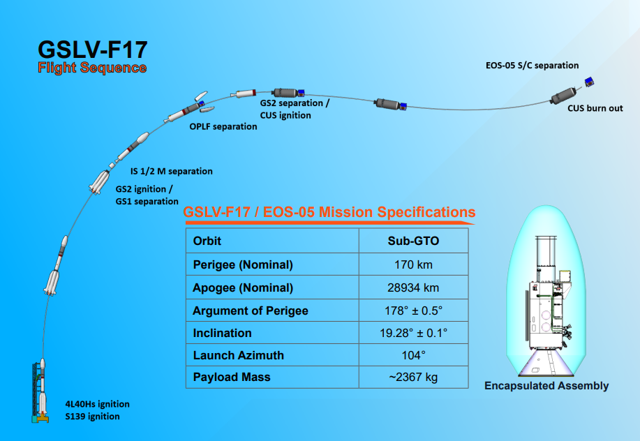
- GSLV-F17 placed the satellite in the intended Sub-Geosynchronous Transfer Orbit, from where it will reach its operational orbit using onboard propulsion.
About EOS-05
EOS-05 is a state-of-the-art Earth-observation spacecraft designed to provide persistent and high-frequency imaging of large geographical regions.
| Feature | Details |
| Satellite type | Earth Observation |
| Payload mass | Approximately 2,367 kg |
| Launch vehicle | GSLV-F17 |
| Launch pad | Second Launch Pad |
| Launch centre | Satish Dhawan Space Centre-SHAR, Sriharikota |
| Initial orbit | Sub-Geosynchronous Transfer Orbit |
| Distinct feature | India’s first imaging satellite from geosynchronous orbit |
| Official Sub-GTO Parameters
These parameters were specified in ISRO’s official mission brochure. |
 About GSLV-F17
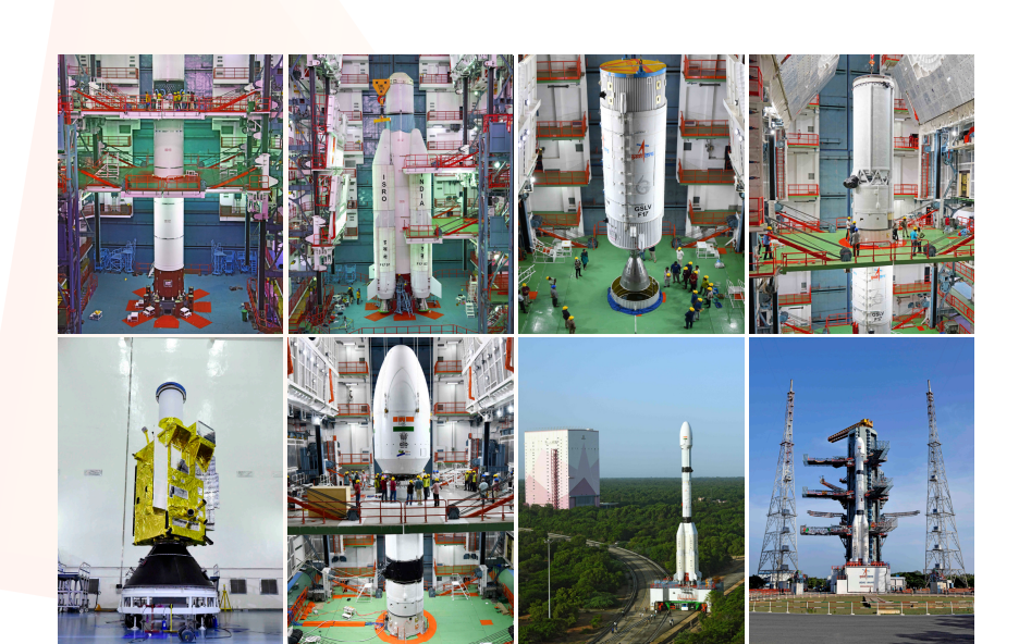
GSLV-F17 was the 19th flight of India’s Geosynchronous Satellite Launch Vehicle.
Important Specifications
- Height: 51.7 metres
- Lift-off mass: 420.5 tonnes
- Number of stages: Three
- Payload fairing: Four-metre-diameter ogive composite version
Three Stages of GSLV-F17
- First stage—GS1: S139 solid core with four L40H liquid strap-ons
- Second stage—GS2: GL40HT liquid stage
- Third stage—GS3: CUS15 cryogenic upper stage
The cryogenic stage uses liquid hydrogen and liquid oxygen. Cryogenic propulsion provides the high velocity required to place heavy satellites into transfer orbits.
GSLV Mk II:
- It is an Indian three-stage launch vehicle with four liquid strap-ons.
- It is designed mainly to launch heavier satellites into transfer orbits.
- Its published capacity is approximately:
- 2,250 kg to GTO; and
- 6,000 kg to LEO.
- The first GSLV flight took place on 18 April 2001.
- Its indigenously developed cryogenic stage was inducted from the GSLV-D5 mission in January 2014.
Because EOS-05 weighs about 2,367 kg, it was placed in a lower-energy Sub-GTO, instead of a standard GTO. This allowed the GSLV to carry the heavier spacecraft, which subsequently uses its own propulsion to reach the final orbit.
What is a Satellite Orbit?
An orbit is the curved path followed by a satellite around Earth under the influence of gravity.
The choice of orbit determines:
- geographical coverage;
- image resolution;
- revisit time;
- communication delay;
- fuel requirement; and
- mission application.
Major Types of Satellite Orbits
| Orbit | Approximate altitude | Major advantage | Major application |
| LEO | 160–2,000 km | High resolution and low latency | Earth observation and communication |
| MEO | 2,000–35,786 km | Wider coverage with moderate latency | Navigation |
| GSO/GEO | Around 35,786 km | Persistent regional coverage | Communication, weather and imaging |
Low Earth Orbit
- Located approximately 160–2,000 km above Earth.
- Satellites generally complete an orbit in 90–120 minutes.
- Proximity to Earth allows high-resolution imaging and low communication delay.
- However, a satellite observes a particular location only briefly during each pass.
- The International Space Station is located in LEO.
As of September 4, 2026, approximately 15,562 active payload satellites were reported in LEO. An April 2026 ISRO report placed India’s operational LEO satellites at 22.
Very Low Earth Orbit
VLEO is the lower part of LEO.
- It permits sharper imaging because satellites are closer to Earth.
- Greater atmospheric drag increases fuel use and can reduce mission life.
Sun-Synchronous Orbit
A Sun-Synchronous Orbit is usually a near-polar LEO in which a satellite crosses a location at nearly the same local solar time.
Similar lighting conditions make it useful for:
- mapping;
- agriculture;
- forest monitoring;
- environmental observation; and
- comparison of images over time.
Medium Earth Orbit
- Extends from approximately 2,000 km to below 35,786 km.
- Provides wider coverage than LEO with less signal delay than GEO.
- Mainly used for global navigation systems.
- Galileo, the European navigation system, comprises a constellation of 30 satellites.
Geosynchronous Orbit
A geosynchronous satellite has an orbital period equal to Earth’s rotation period—approximately 23 hours and 56 minutes.
- It returns to the same position in the sky at the same time every day.
- Its orbit may be circular or elliptical.
- It may also be inclined.
- Therefore, it does not necessarily appear permanently stationary.
Geostationary Orbit
A geostationary orbit is a special type of geosynchronous orbit.
It must be:
- circular;
- directly above the equator;
- moving from west to east;
- at zero-degree inclination; and
- matched with Earth’s rotation.
Therefore, the satellite appears fixed over one location. India was reported to have 31 operational satellites in geostationary orbit.
Geosynchronous and Geostationary Orbits
| Geosynchronous Orbit | Geostationary Orbit |
| May be circular or elliptical | Must be circular |
| May be inclined | Must have zero inclination |
| Satellite may appear to move | Satellite appears stationary |
| Broad orbital category | Special subset of geosynchronous orbit |
What is a Geosynchronous Transfer Orbit?
A Geosynchronous Transfer Orbit is a temporary, highly elliptical orbit used to move a satellite towards its final geosynchronous or geostationary orbit.
Orbital-Raising Process
- The rocket places the satellite in GTO or Sub-GTO.
- The satellite separates from the launch vehicle.
- Its onboard propulsion raises the lower point of the orbit.
- The orbit is gradually circularised.
- The inclination is corrected to reach the operational orbit.
This method reduces the fuel and energy required from the launch vehicle.
Why is EOS-05 Significant?
- Persistent observation: Provides frequent imaging of large regions, unlike the periodic passes of a single LEO satellite.
- Disaster management: Supports real-time monitoring of cyclones, floods, landslides and forest fires.
- Agriculture: Helps assess crop health, drought, irrigation and agricultural stress.
- Natural resources: Monitors forests, water bodies, coasts and land-use changes.
- Maritime security: Strengthens observation of India’s coastal and maritime regions.
- Strategic awareness: Supports monitoring of borders and critical infrastructure.
- Geospatial economy: Provides high-frequency data for mapping, insurance, logistics and private geospatial services.
- Technological capability: Demonstrates ISRO’s ability to place a spacecraft heavier than the standard GSLV GTO capacity into a carefully selected Sub-GTO.
What are the Limitations?
- High altitude generally produces lower spatial resolution than LEO imaging.
- Orbit raising and station-keeping consume onboard fuel.
- The orbit is disturbed by the gravity of the Sun and Moon, Earth’s uneven gravitational field and solar-radiation pressure.
- High-frequency observation produces large data volumes requiring rapid processing.
- High-altitude missions involve greater launch and operational costs.
Conclusion
EOS-05 strengthens India’s Earth-observation architecture through persistent imaging of large regions. When combined with high-resolution LEO satellites, it can improve disaster response, agriculture, environmental governance and strategic awareness. The mission also demonstrates India’s growing capability in launch-vehicle optimisation, cryogenic technology and space-based governance.